You are here: Home > Network List > TA - USArray Transportable Network (new EarthScope stations) Stations List
> Station A18A Metzger Ranch, Havre, MT, USA > Earthquake Result Viewer
A18A Metzger Ranch, Havre, MT, USA - Earthquake Result Viewer
| Earthquake location: |
Central Mid-Atlantic Ridge |
| Earthquake latitude/longitude: |
8.1/-38.7 |
| Earthquake time(UTC): |
2008/09/10 (254) 13:08:14 GMT |
| Earthquake Depth: |
10 km |
| Earthquake Magnitude: |
6.3 MB, 6.5 MS, 6.6 MW, 6.6 MW |
| Earthquake Catalog/Contributor: |
WHDF/NEIC |
|
| Network: |
TA USArray Transportable Network (new EarthScope stations) |
| Station: |
A18A Metzger Ranch, Havre, MT, USA |
| Lat/Lon: |
48.92 N/109.85 W |
| Elevation: |
804 m |
|
| Distance: |
71.6 deg |
| Az: |
318.856 deg |
| Baz: |
99.005 deg |
| Ray Param: |
0.054248925 |
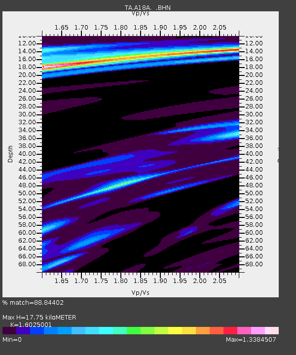
| Estimated Moho Depth: |
17.75 km |
| Estimated Crust Vp/Vs: |
1.60 |
| Assumed Crust Vp: |
6.438 km/s |
| Estimated Crust Vs: |
4.017 km/s |
| Estimated Crust Poisson's Ratio: |
0.18 |
|
| Radial Match: |
88.84402 % |
| Radial Bump: |
289 |
| Transverse Match: |
81.94026 % |
| Transverse Bump: |
368 |
| SOD ConfigId: |
2560 |
| Insert Time: |
2010-03-06 02:41:48.323 +0000 |
| GWidth: |
2.5 |
| Max Bumps: |
400 |
| Tol: |
0.001 |
|
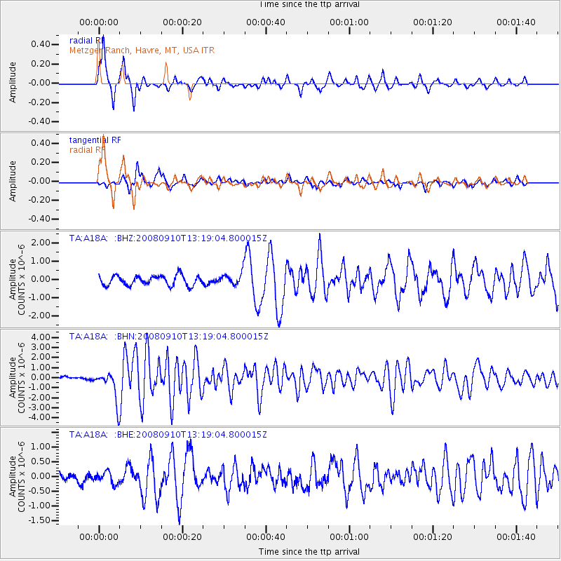
Signal To Noise
| Channel | StoN | STA | LTA |
| TA:A18A: :BHN:20080910T13:19:04.800015Z | 10.848573 | 1.5377406E-6 | 1.4174589E-7 |
| TA:A18A: :BHE:20080910T13:19:04.800015Z | 1.0308684 | 2.0383386E-7 | 1.9773024E-7 |
| TA:A18A: :BHZ:20080910T13:19:04.800015Z | 1.4422337 | 3.8077076E-7 | 2.640146E-7 |
| Arrivals |
| Ps | 1.7 SECOND |
| PpPs | 6.9 SECOND |
| PsPs/PpSs | 8.6 SECOND |


