You are here: Home > Network List > TA - USArray Transportable Network (new EarthScope stations) Stations List
> Station E18K Tukpahlearik Creek, AK, USA > Earthquake Result Viewer
E18K Tukpahlearik Creek, AK, USA - Earthquake Result Viewer
| Earthquake location: |
Northern Xinjiang, China |
| Earthquake latitude/longitude: |
44.3/82.8 |
| Earthquake time(UTC): |
2017/08/08 (220) 23:27:53 GMT |
| Earthquake Depth: |
20 km |
| Earthquake Magnitude: |
6.3 Mww |
| Earthquake Catalog/Contributor: |
NEIC PDE/us |
|
| Network: |
TA USArray Transportable Network (new EarthScope stations) |
| Station: |
E18K Tukpahlearik Creek, AK, USA |
| Lat/Lon: |
67.42 N/160.60 W |
| Elevation: |
297 m |
|
| Distance: |
58.8 deg |
| Az: |
23.818 deg |
| Baz: |
311.338 deg |
| Ray Param: |
0.0625893 |
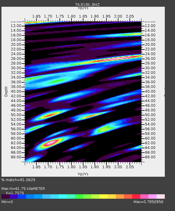
| Estimated Moho Depth: |
61.75 km |
| Estimated Crust Vp/Vs: |
1.71 |
| Assumed Crust Vp: |
6.276 km/s |
| Estimated Crust Vs: |
3.675 km/s |
| Estimated Crust Poisson's Ratio: |
0.24 |
|
| Radial Match: |
91.0625 % |
| Radial Bump: |
400 |
| Transverse Match: |
80.68801 % |
| Transverse Bump: |
400 |
| SOD ConfigId: |
13570011 |
| Insert Time: |
2019-04-28 13:39:05.417 +0000 |
| GWidth: |
2.5 |
| Max Bumps: |
400 |
| Tol: |
0.001 |
|
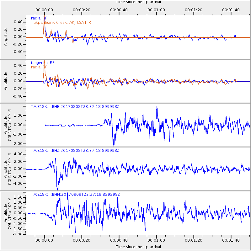
Signal To Noise
| Channel | StoN | STA | LTA |
| TA:E18K: :BHZ:20170808T23:37:18.899998Z | 15.673741 | 9.1677674E-7 | 5.8491253E-8 |
| TA:E18K: :BHN:20170808T23:37:18.899998Z | 6.7354307 | 2.7436556E-7 | 4.0734673E-8 |
| TA:E18K: :BHE:20170808T23:37:18.899998Z | 7.4553747 | 3.2289918E-7 | 4.3310923E-8 |
| Arrivals |
| Ps | 7.3 SECOND |
| PpPs | 25 SECOND |
| PsPs/PpSs | 33 SECOND |


