You are here: Home > Network List > TA - USArray Transportable Network (new EarthScope stations) Stations List
> Station A18A Metzger Ranch, Havre, MT, USA > Earthquake Result Viewer
A18A Metzger Ranch, Havre, MT, USA - Earthquake Result Viewer
| Earthquake location: |
Kermadec Islands Region |
| Earthquake latitude/longitude: |
-27.4/-176.3 |
| Earthquake time(UTC): |
2009/02/18 (049) 21:53:45 GMT |
| Earthquake Depth: |
25 km |
| Earthquake Magnitude: |
6.8 MB, 7.2 MS, 6.9 MW, 6.9 MW |
| Earthquake Catalog/Contributor: |
WHDF/NEIC |
|
| Network: |
TA USArray Transportable Network (new EarthScope stations) |
| Station: |
A18A Metzger Ranch, Havre, MT, USA |
| Lat/Lon: |
48.92 N/109.85 W |
| Elevation: |
804 m |
|
| Distance: |
96.3 deg |
| Az: |
37.485 deg |
| Baz: |
235.092 deg |
| Ray Param: |
0.040534288 |
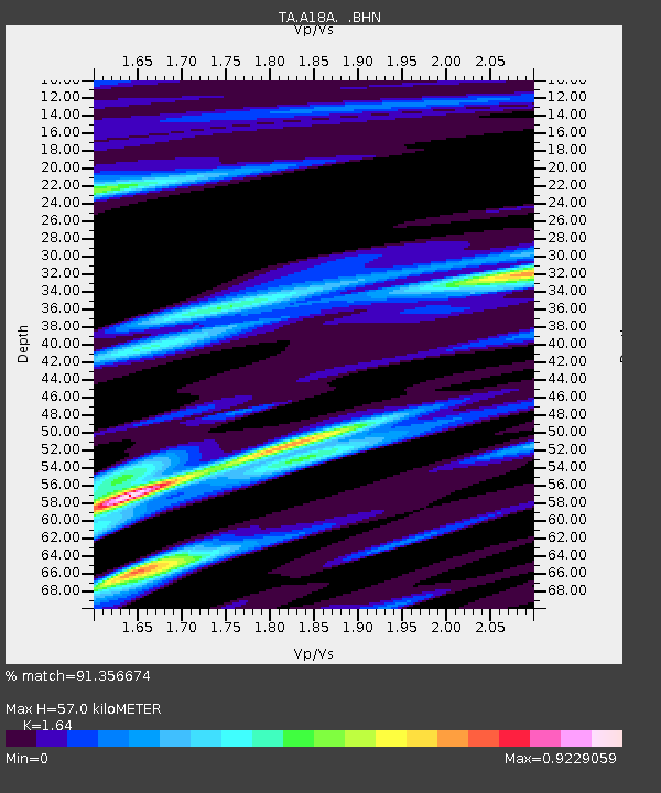
| Estimated Moho Depth: |
57.0 km |
| Estimated Crust Vp/Vs: |
1.64 |
| Assumed Crust Vp: |
6.438 km/s |
| Estimated Crust Vs: |
3.925 km/s |
| Estimated Crust Poisson's Ratio: |
0.20 |
|
| Radial Match: |
91.356674 % |
| Radial Bump: |
352 |
| Transverse Match: |
67.88716 % |
| Transverse Bump: |
305 |
| SOD ConfigId: |
2658 |
| Insert Time: |
2010-03-06 02:41:54.717 +0000 |
| GWidth: |
2.5 |
| Max Bumps: |
400 |
| Tol: |
0.001 |
|
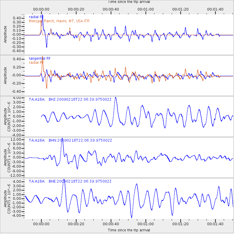
Signal To Noise
| Channel | StoN | STA | LTA |
| TA:A18A: :BHN:20090218T22:06:39.975002Z | 1.959685 | 7.541095E-7 | 3.8481159E-7 |
| TA:A18A: :BHE:20090218T22:06:39.975002Z | 0.6248344 | 5.116773E-7 | 8.189006E-7 |
| TA:A18A: :BHZ:20090218T22:06:39.975002Z | 2.0882783 | 1.0989855E-6 | 5.2626393E-7 |
| Arrivals |
| Ps | 5.8 SECOND |
| PpPs | 23 SECOND |
| PsPs/PpSs | 29 SECOND |


