You are here: Home > Network List > TA - USArray Transportable Network (new EarthScope stations) Stations List
> Station A18A Metzger Ranch, Havre, MT, USA > Earthquake Result Viewer
A18A Metzger Ranch, Havre, MT, USA - Earthquake Result Viewer
| Earthquake location: |
Near S. Coast Of Honshu, Japan |
| Earthquake latitude/longitude: |
33.2/137.9 |
| Earthquake time(UTC): |
2009/08/09 (221) 10:55:55 GMT |
| Earthquake Depth: |
297 km |
| Earthquake Magnitude: |
6.5 MB, 7.1 MW, 7.1 MW |
| Earthquake Catalog/Contributor: |
WHDF/NEIC |
|
| Network: |
TA USArray Transportable Network (new EarthScope stations) |
| Station: |
A18A Metzger Ranch, Havre, MT, USA |
| Lat/Lon: |
48.92 N/109.85 W |
| Elevation: |
804 m |
|
| Distance: |
78.5 deg |
| Az: |
38.555 deg |
| Baz: |
307.577 deg |
| Ray Param: |
0.048831098 |
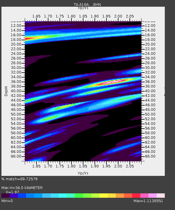
| Estimated Moho Depth: |
36.0 km |
| Estimated Crust Vp/Vs: |
1.97 |
| Assumed Crust Vp: |
6.438 km/s |
| Estimated Crust Vs: |
3.268 km/s |
| Estimated Crust Poisson's Ratio: |
0.33 |
|
| Radial Match: |
89.72579 % |
| Radial Bump: |
400 |
| Transverse Match: |
75.9106 % |
| Transverse Bump: |
400 |
| SOD ConfigId: |
2622 |
| Insert Time: |
2010-03-06 02:41:58.158 +0000 |
| GWidth: |
2.5 |
| Max Bumps: |
400 |
| Tol: |
0.001 |
|

Signal To Noise
| Channel | StoN | STA | LTA |
| TA:A18A: :BHN:20090809T11:06:52.875015Z | 145.91685 | 1.3804491E-5 | 9.4605184E-8 |
| TA:A18A: :BHE:20090809T11:06:52.875015Z | 11.116523 | 2.2215288E-6 | 1.9984026E-7 |
| TA:A18A: :BHZ:20090809T11:06:52.875015Z | 20.673302 | 4.137834E-6 | 2.0015351E-7 |
| Arrivals |
| Ps | 5.6 SECOND |
| PpPs | 16 SECOND |
| PsPs/PpSs | 22 SECOND |


