You are here: Home > Network List > TA - USArray Transportable Network (new EarthScope stations) Stations List
> Station G26K Porcupine River, AK, USA > Earthquake Result Viewer
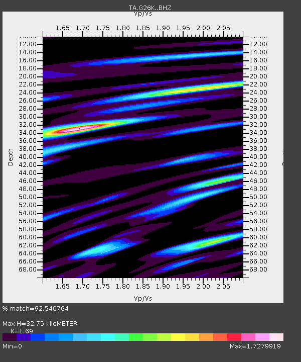
G26K Porcupine River, AK, USA - Earthquake Result Viewer
| Earthquake location: |
Northern Xinjiang, China |
| Earthquake latitude/longitude: |
44.3/82.8 |
| Earthquake time(UTC): |
2017/08/08 (220) 23:27:53 GMT |
| Earthquake Depth: |
20 km |
| Earthquake Magnitude: |
6.3 Mww |
| Earthquake Catalog/Contributor: |
NEIC PDE/us |
|
| Network: |
TA USArray Transportable Network (new EarthScope stations) |
| Station: |
G26K Porcupine River, AK, USA |
| Lat/Lon: |
66.95 N/143.78 W |
| Elevation: |
180 m |
|
| Distance: |
63.5 deg |
| Az: |
18.645 deg |
| Baz: |
324.344 deg |
| Ray Param: |
0.0594934 |
| Estimated Moho Depth: |
32.75 km |
| Estimated Crust Vp/Vs: |
1.69 |
| Assumed Crust Vp: |
6.577 km/s |
| Estimated Crust Vs: |
3.892 km/s |
| Estimated Crust Poisson's Ratio: |
0.23 |
|
| Radial Match: |
92.540764 % |
| Radial Bump: |
400 |
| Transverse Match: |
85.323105 % |
| Transverse Bump: |
400 |
| SOD ConfigId: |
13570011 |
| Insert Time: |
2019-04-28 13:39:27.769 +0000 |
| GWidth: |
2.5 |
| Max Bumps: |
400 |
| Tol: |
0.001 |
|

Signal To Noise
| Channel | StoN | STA | LTA |
| TA:G26K: :BHZ:20170808T23:37:50.949985Z | 14.289762 | 8.3788024E-7 | 5.8635003E-8 |
| TA:G26K: :BHN:20170808T23:37:50.949985Z | 6.876868 | 3.5958814E-7 | 5.2289522E-8 |
| TA:G26K: :BHE:20170808T23:37:50.949985Z | 3.4653444 | 2.1261212E-7 | 6.1353816E-8 |
| Arrivals |
| Ps | 3.6 SECOND |
| PpPs | 13 SECOND |
| PsPs/PpSs | 16 SECOND |


