You are here: Home > Network List > TA - USArray Transportable Network (new EarthScope stations) Stations List
> Station J14K Nanvaranak Lake, AK, USA > Earthquake Result Viewer
J14K Nanvaranak Lake, AK, USA - Earthquake Result Viewer
| Earthquake location: |
Northern Xinjiang, China |
| Earthquake latitude/longitude: |
44.3/82.8 |
| Earthquake time(UTC): |
2017/08/08 (220) 23:27:53 GMT |
| Earthquake Depth: |
20 km |
| Earthquake Magnitude: |
6.3 Mww |
| Earthquake Catalog/Contributor: |
NEIC PDE/us |
|
| Network: |
TA USArray Transportable Network (new EarthScope stations) |
| Station: |
J14K Nanvaranak Lake, AK, USA |
| Lat/Lon: |
62.75 N/163.55 W |
| Elevation: |
25 m |
|
| Distance: |
60.9 deg |
| Az: |
28.848 deg |
| Baz: |
311.189 deg |
| Ray Param: |
0.061171513 |
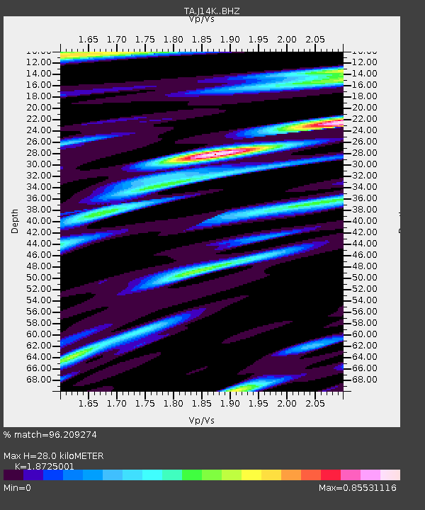
| Estimated Moho Depth: |
28.0 km |
| Estimated Crust Vp/Vs: |
1.87 |
| Assumed Crust Vp: |
6.155 km/s |
| Estimated Crust Vs: |
3.287 km/s |
| Estimated Crust Poisson's Ratio: |
0.30 |
|
| Radial Match: |
96.209274 % |
| Radial Bump: |
400 |
| Transverse Match: |
82.35951 % |
| Transverse Bump: |
400 |
| SOD ConfigId: |
13570011 |
| Insert Time: |
2019-04-28 13:39:44.307 +0000 |
| GWidth: |
2.5 |
| Max Bumps: |
400 |
| Tol: |
0.001 |
|

Signal To Noise
| Channel | StoN | STA | LTA |
| TA:J14K: :BHZ:20170808T23:37:33.675022Z | 11.34069 | 8.1164876E-7 | 7.1569616E-8 |
| TA:J14K: :BHN:20170808T23:37:33.675022Z | 5.240172 | 2.4390044E-7 | 4.6544354E-8 |
| TA:J14K: :BHE:20170808T23:37:33.675022Z | 5.938992 | 2.6964548E-7 | 4.5402565E-8 |
| Arrivals |
| Ps | 4.1 SECOND |
| PpPs | 13 SECOND |
| PsPs/PpSs | 17 SECOND |


