You are here: Home > Network List > TA - USArray Transportable Network (new EarthScope stations) Stations List
> Station J20K Nowitna River, AK, USA > Earthquake Result Viewer
J20K Nowitna River, AK, USA - Earthquake Result Viewer
| Earthquake location: |
Northern Xinjiang, China |
| Earthquake latitude/longitude: |
44.3/82.8 |
| Earthquake time(UTC): |
2017/08/08 (220) 23:27:53 GMT |
| Earthquake Depth: |
20 km |
| Earthquake Magnitude: |
6.3 Mww |
| Earthquake Catalog/Contributor: |
NEIC PDE/us |
|
| Network: |
TA USArray Transportable Network (new EarthScope stations) |
| Station: |
J20K Nowitna River, AK, USA |
| Lat/Lon: |
64.18 N/154.15 W |
| Elevation: |
314 m |
|
| Distance: |
63.0 deg |
| Az: |
24.347 deg |
| Baz: |
317.482 deg |
| Ray Param: |
0.05985708 |
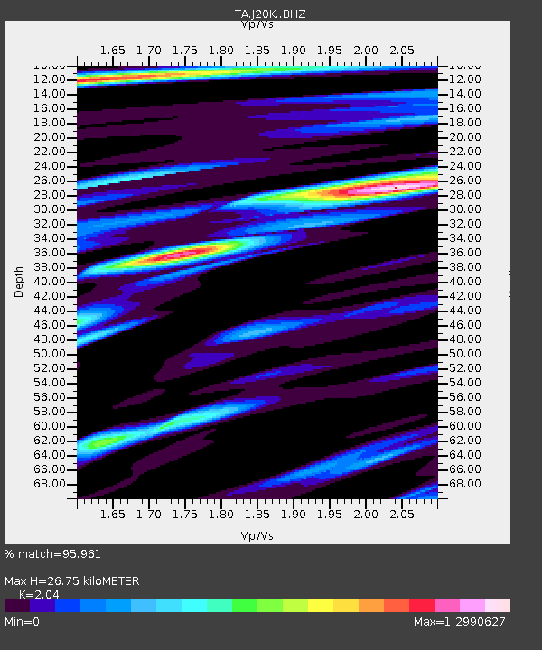
| Estimated Moho Depth: |
26.75 km |
| Estimated Crust Vp/Vs: |
2.04 |
| Assumed Crust Vp: |
6.566 km/s |
| Estimated Crust Vs: |
3.219 km/s |
| Estimated Crust Poisson's Ratio: |
0.34 |
|
| Radial Match: |
95.961 % |
| Radial Bump: |
358 |
| Transverse Match: |
89.83328 % |
| Transverse Bump: |
400 |
| SOD ConfigId: |
13570011 |
| Insert Time: |
2019-04-28 13:39:47.541 +0000 |
| GWidth: |
2.5 |
| Max Bumps: |
400 |
| Tol: |
0.001 |
|

Signal To Noise
| Channel | StoN | STA | LTA |
| TA:J20K: :BHZ:20170808T23:37:47.249973Z | 14.81512 | 8.202482E-7 | 5.5365614E-8 |
| TA:J20K: :BHN:20170808T23:37:47.249973Z | 7.98867 | 2.813145E-7 | 3.521419E-8 |
| TA:J20K: :BHE:20170808T23:37:47.249973Z | 5.289768 | 2.2973437E-7 | 4.342995E-8 |
| Arrivals |
| Ps | 4.4 SECOND |
| PpPs | 12 SECOND |
| PsPs/PpSs | 16 SECOND |


