You are here: Home > Network List > TA - USArray Transportable Network (new EarthScope stations) Stations List
> Station L14K Kuka Creek, AK, USA > Earthquake Result Viewer
L14K Kuka Creek, AK, USA - Earthquake Result Viewer
| Earthquake location: |
Northern Xinjiang, China |
| Earthquake latitude/longitude: |
44.3/82.8 |
| Earthquake time(UTC): |
2017/08/08 (220) 23:27:53 GMT |
| Earthquake Depth: |
20 km |
| Earthquake Magnitude: |
6.3 Mww |
| Earthquake Catalog/Contributor: |
NEIC PDE/us |
|
| Network: |
TA USArray Transportable Network (new EarthScope stations) |
| Station: |
L14K Kuka Creek, AK, USA |
| Lat/Lon: |
61.34 N/162.68 W |
| Elevation: |
41 m |
|
| Distance: |
62.2 deg |
| Az: |
29.735 deg |
| Baz: |
312.38 deg |
| Ray Param: |
0.060363356 |
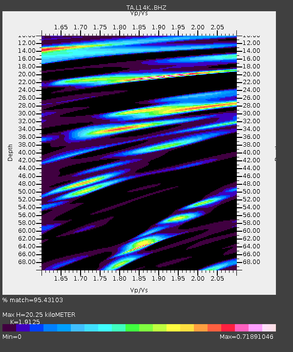
| Estimated Moho Depth: |
20.25 km |
| Estimated Crust Vp/Vs: |
1.91 |
| Assumed Crust Vp: |
6.1 km/s |
| Estimated Crust Vs: |
3.19 km/s |
| Estimated Crust Poisson's Ratio: |
0.31 |
|
| Radial Match: |
95.43103 % |
| Radial Bump: |
400 |
| Transverse Match: |
80.463264 % |
| Transverse Bump: |
400 |
| SOD ConfigId: |
13570011 |
| Insert Time: |
2019-04-28 13:39:57.568 +0000 |
| GWidth: |
2.5 |
| Max Bumps: |
400 |
| Tol: |
0.001 |
|

Signal To Noise
| Channel | StoN | STA | LTA |
| TA:L14K: :BHZ:20170808T23:37:42.074985Z | 13.222383 | 8.847117E-7 | 6.691016E-8 |
| TA:L14K: :BHN:20170808T23:37:42.074985Z | 3.4619083 | 3.0478398E-7 | 8.80393E-8 |
| TA:L14K: :BHE:20170808T23:37:42.074985Z | 4.2556515 | 2.8549613E-7 | 6.7086354E-8 |
| Arrivals |
| Ps | 3.1 SECOND |
| PpPs | 9.3 SECOND |
| PsPs/PpSs | 12 SECOND |


