You are here: Home > Network List > TA - USArray Transportable Network (new EarthScope stations) Stations List
> Station A18A Metzger Ranch, Havre, MT, USA > Earthquake Result Viewer
A18A Metzger Ranch, Havre, MT, USA - Earthquake Result Viewer
| Earthquake location: |
North Of Svalbard |
| Earthquake latitude/longitude: |
80.3/-1.9 |
| Earthquake time(UTC): |
2009/03/06 (065) 10:50:29 GMT |
| Earthquake Depth: |
9.0 km |
| Earthquake Magnitude: |
6.6 MB, 6.5 MS, 6.5 MW, 6.4 MW |
| Earthquake Catalog/Contributor: |
WHDF/NEIC |
|
| Network: |
TA USArray Transportable Network (new EarthScope stations) |
| Station: |
A18A Metzger Ranch, Havre, MT, USA |
| Lat/Lon: |
48.92 N/109.85 W |
| Elevation: |
804 m |
|
| Distance: |
45.1 deg |
| Az: |
297.6 deg |
| Baz: |
13.138 deg |
| Ray Param: |
0.07152654 |
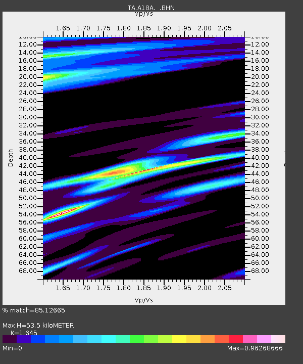
| Estimated Moho Depth: |
53.5 km |
| Estimated Crust Vp/Vs: |
1.64 |
| Assumed Crust Vp: |
6.438 km/s |
| Estimated Crust Vs: |
3.913 km/s |
| Estimated Crust Poisson's Ratio: |
0.21 |
|
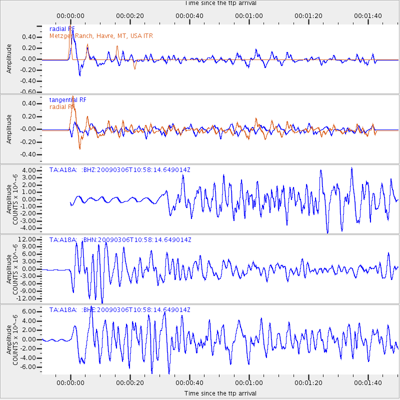
| Radial Match: |
85.12665 % |
| Radial Bump: |
388 |
| Transverse Match: |
74.451035 % |
| Transverse Bump: |
400 |
| SOD ConfigId: |
2658 |
| Insert Time: |
2010-03-06 02:42:15.225 +0000 |
| GWidth: |
2.5 |
| Max Bumps: |
400 |
| Tol: |
0.001 |
|
Signal To Noise
| Channel | StoN | STA | LTA |
| TA:A18A: :BHN:20090306T10:58:14.649014Z | 55.930702 | 5.8907E-6 | 1.053214E-7 |
| TA:A18A: :BHE:20090306T10:58:14.649014Z | 9.3152075 | 3.005309E-6 | 3.2262395E-7 |
| TA:A18A: :BHZ:20090306T10:58:14.649014Z | 3.608214 | 1.046876E-6 | 2.901369E-7 |
| Arrivals |
| Ps | 5.7 SECOND |
| PpPs | 21 SECOND |
| PsPs/PpSs | 26 SECOND |


