You are here: Home > Network List > TA - USArray Transportable Network (new EarthScope stations) Stations List
> Station M23K Glacier View, AK, USA > Earthquake Result Viewer
M23K Glacier View, AK, USA - Earthquake Result Viewer
| Earthquake location: |
Northern Xinjiang, China |
| Earthquake latitude/longitude: |
44.3/82.8 |
| Earthquake time(UTC): |
2017/08/08 (220) 23:27:53 GMT |
| Earthquake Depth: |
20 km |
| Earthquake Magnitude: |
6.3 Mww |
| Earthquake Catalog/Contributor: |
NEIC PDE/us |
|
| Network: |
TA USArray Transportable Network (new EarthScope stations) |
| Station: |
M23K Glacier View, AK, USA |
| Lat/Lon: |
61.79 N/147.73 W |
| Elevation: |
583 m |
|
| Distance: |
66.7 deg |
| Az: |
23.552 deg |
| Baz: |
322.857 deg |
| Ray Param: |
0.057431508 |
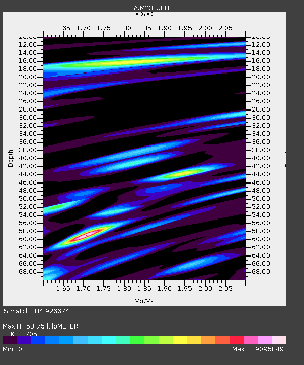
| Estimated Moho Depth: |
58.75 km |
| Estimated Crust Vp/Vs: |
1.71 |
| Assumed Crust Vp: |
6.566 km/s |
| Estimated Crust Vs: |
3.851 km/s |
| Estimated Crust Poisson's Ratio: |
0.24 |
|
| Radial Match: |
84.926674 % |
| Radial Bump: |
400 |
| Transverse Match: |
81.34148 % |
| Transverse Bump: |
400 |
| SOD ConfigId: |
13570011 |
| Insert Time: |
2019-04-28 13:40:13.013 +0000 |
| GWidth: |
2.5 |
| Max Bumps: |
400 |
| Tol: |
0.001 |
|

Signal To Noise
| Channel | StoN | STA | LTA |
| TA:M23K: :BHZ:20170808T23:38:11.374973Z | 22.925686 | 1.5885834E-6 | 6.9292724E-8 |
| TA:M23K: :BHN:20170808T23:38:11.374973Z | 10.192719 | 7.8246023E-7 | 7.676658E-8 |
| TA:M23K: :BHE:20170808T23:38:11.374973Z | 3.5724127 | 4.7606395E-7 | 1.3326118E-7 |
| Arrivals |
| Ps | 6.6 SECOND |
| PpPs | 23 SECOND |
| PsPs/PpSs | 30 SECOND |


