You are here: Home > Network List > TA - USArray Transportable Network (new EarthScope stations) Stations List
> Station M31M Drury Creek, Yukon, CA > Earthquake Result Viewer
M31M Drury Creek, Yukon, CA - Earthquake Result Viewer
| Earthquake location: |
Northern Xinjiang, China |
| Earthquake latitude/longitude: |
44.3/82.8 |
| Earthquake time(UTC): |
2017/08/08 (220) 23:27:53 GMT |
| Earthquake Depth: |
20 km |
| Earthquake Magnitude: |
6.3 Mww |
| Earthquake Catalog/Contributor: |
NEIC PDE/us |
|
| Network: |
TA USArray Transportable Network (new EarthScope stations) |
| Station: |
M31M Drury Creek, Yukon, CA |
| Lat/Lon: |
62.20 N/134.39 W |
| Elevation: |
639 m |
|
| Distance: |
69.7 deg |
| Az: |
17.601 deg |
| Baz: |
332.413 deg |
| Ray Param: |
0.055448763 |
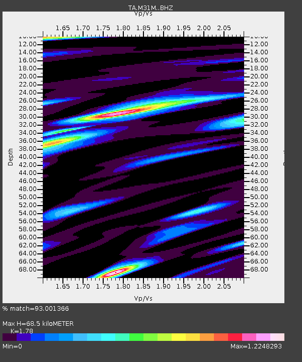
| Estimated Moho Depth: |
68.5 km |
| Estimated Crust Vp/Vs: |
1.78 |
| Assumed Crust Vp: |
6.419 km/s |
| Estimated Crust Vs: |
3.606 km/s |
| Estimated Crust Poisson's Ratio: |
0.27 |
|
| Radial Match: |
93.001366 % |
| Radial Bump: |
382 |
| Transverse Match: |
88.003365 % |
| Transverse Bump: |
400 |
| SOD ConfigId: |
13570011 |
| Insert Time: |
2019-04-28 13:40:17.235 +0000 |
| GWidth: |
2.5 |
| Max Bumps: |
400 |
| Tol: |
0.001 |
|
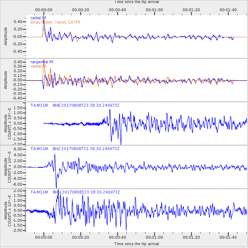
Signal To Noise
| Channel | StoN | STA | LTA |
| TA:M31M: :BHZ:20170808T23:38:30.249973Z | 12.566374 | 8.7052683E-7 | 6.927431E-8 |
| TA:M31M: :BHN:20170808T23:38:30.249973Z | 3.9925275 | 2.9546493E-7 | 7.400448E-8 |
| TA:M31M: :BHE:20170808T23:38:30.249973Z | 4.1602745 | 2.400201E-7 | 5.7693335E-8 |
| Arrivals |
| Ps | 8.6 SECOND |
| PpPs | 29 SECOND |
| PsPs/PpSs | 37 SECOND |


