You are here: Home > Network List > TA - USArray Transportable Network (new EarthScope stations) Stations List
> Station N25K Chitina, Valdez-Cordova, AK, USA > Earthquake Result Viewer
N25K Chitina, Valdez-Cordova, AK, USA - Earthquake Result Viewer

| Earthquake location: |
Northern Xinjiang, China |
| Earthquake latitude/longitude: |
44.3/82.8 |
| Earthquake time(UTC): |
2017/08/08 (220) 23:27:53 GMT |
| Earthquake Depth: |
20 km |
| Earthquake Magnitude: |
6.3 Mww |
| Earthquake Catalog/Contributor: |
NEIC PDE/us |
|
| Network: |
TA USArray Transportable Network (new EarthScope stations) |
| Station: |
N25K Chitina, Valdez-Cordova, AK, USA |
| Lat/Lon: |
61.61 N/144.60 W |
| Elevation: |
1087 m |
|
| Distance: |
67.7 deg |
| Az: |
22.363 deg |
| Baz: |
325.147 deg |
| Ray Param: |
0.05675711 |
| Estimated Moho Depth: |
16.0 km |
| Estimated Crust Vp/Vs: |
2.10 |
| Assumed Crust Vp: |
6.566 km/s |
| Estimated Crust Vs: |
3.13 km/s |
| Estimated Crust Poisson's Ratio: |
0.35 |
|
| Radial Match: |
95.97013 % |
| Radial Bump: |
400 |
| Transverse Match: |
92.228714 % |
| Transverse Bump: |
400 |
| SOD ConfigId: |
13570011 |
| Insert Time: |
2019-04-28 13:40:26.620 +0000 |
| GWidth: |
2.5 |
| Max Bumps: |
400 |
| Tol: |
0.001 |
|
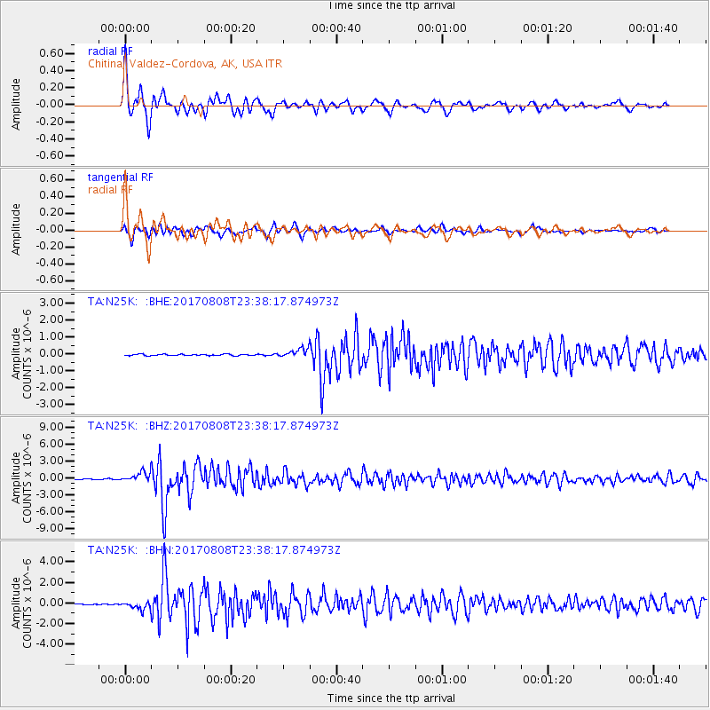
Signal To Noise
| Channel | StoN | STA | LTA |
| TA:N25K: :BHZ:20170808T23:38:17.874973Z | 16.363747 | 9.0004886E-7 | 5.5002612E-8 |
| TA:N25K: :BHN:20170808T23:38:17.874973Z | 6.423116 | 3.6615168E-7 | 5.7005305E-8 |
| TA:N25K: :BHE:20170808T23:38:17.874973Z | 6.1684895 | 2.5326247E-7 | 4.1057454E-8 |
| Arrivals |
| Ps | 2.8 SECOND |
| PpPs | 7.3 SECOND |
| PsPs/PpSs | 10 SECOND |


