You are here: Home > Network List > TA - USArray Transportable Network (new EarthScope stations) Stations List
> Station R17K Ugashik Creek, AK, USA > Earthquake Result Viewer
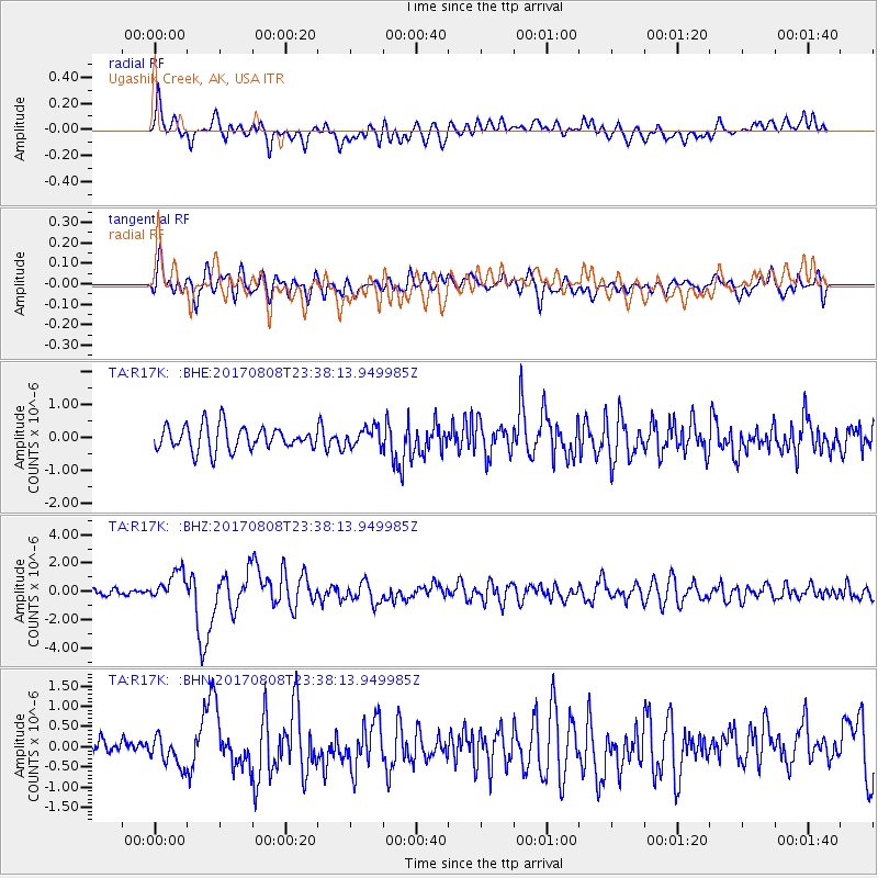
R17K Ugashik Creek, AK, USA - Earthquake Result Viewer
*The percent match for this event was below the threshold and hence no stack was calculated.
| Earthquake location: |
Northern Xinjiang, China |
| Earthquake latitude/longitude: |
44.3/82.8 |
| Earthquake time(UTC): |
2017/08/08 (220) 23:27:53 GMT |
| Earthquake Depth: |
20 km |
| Earthquake Magnitude: |
6.3 Mww |
| Earthquake Catalog/Contributor: |
NEIC PDE/us |
|
| Network: |
TA USArray Transportable Network (new EarthScope stations) |
| Station: |
R17K Ugashik Creek, AK, USA |
| Lat/Lon: |
57.64 N/156.39 W |
| Elevation: |
273 m |
|
| Distance: |
67.1 deg |
| Az: |
30.108 deg |
| Baz: |
317.958 deg |
| Ray Param: |
$rayparam |
*The percent match for this event was below the threshold and hence was not used in the summary stack. |
|
| Radial Match: |
69.68266 % |
| Radial Bump: |
400 |
| Transverse Match: |
58.763332 % |
| Transverse Bump: |
400 |
| SOD ConfigId: |
13570011 |
| Insert Time: |
2019-04-28 13:40:53.472 +0000 |
| GWidth: |
2.5 |
| Max Bumps: |
400 |
| Tol: |
0.001 |
|
Signal To Noise
| Channel | StoN | STA | LTA |
| TA:R17K: :BHZ:20170808T23:38:13.949985Z | 2.3777366 | 1.0185607E-6 | 4.2837408E-7 |
| TA:R17K: :BHN:20170808T23:38:13.949985Z | 1.3227181 | 3.5809938E-7 | 2.7072994E-7 |
| TA:R17K: :BHE:20170808T23:38:13.949985Z | 0.7767985 | 2.8332974E-7 | 3.6474032E-7 |
| Arrivals |
| Ps | |
| PpPs | |
| PsPs/PpSs | |


