You are here: Home > Network List > TA - USArray Transportable Network (new EarthScope stations) Stations List
> Station A18A Metzger Ranch, Havre, MT, USA > Earthquake Result Viewer
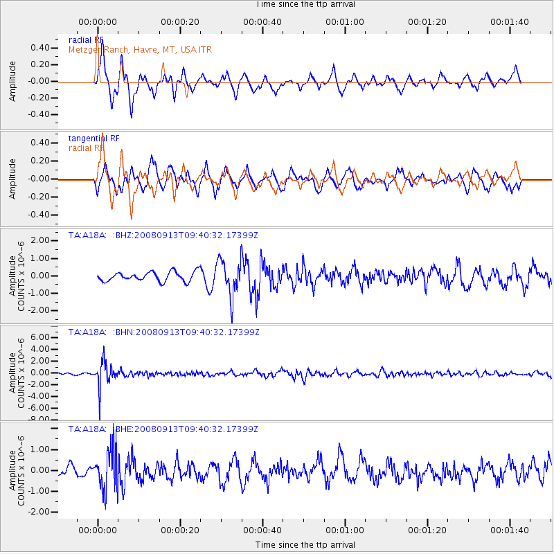
A18A Metzger Ranch, Havre, MT, USA - Earthquake Result Viewer
*The percent match for this event was below the threshold and hence no stack was calculated.
| Earthquake location: |
Colombia |
| Earthquake latitude/longitude: |
4.8/-75.5 |
| Earthquake time(UTC): |
2008/09/13 (257) 09:32:01 GMT |
| Earthquake Depth: |
133 km |
| Earthquake Magnitude: |
5.9 MB, 5.7 MW, 5.7 MW |
| Earthquake Catalog/Contributor: |
WHDF/NEIC |
|
| Network: |
TA USArray Transportable Network (new EarthScope stations) |
| Station: |
A18A Metzger Ranch, Havre, MT, USA |
| Lat/Lon: |
48.92 N/109.85 W |
| Elevation: |
804 m |
|
| Distance: |
52.8 deg |
| Az: |
332.142 deg |
| Baz: |
135.093 deg |
| Ray Param: |
$rayparam |
*The percent match for this event was below the threshold and hence was not used in the summary stack. |
|
| Radial Match: |
67.20233 % |
| Radial Bump: |
361 |
| Transverse Match: |
62.867577 % |
| Transverse Bump: |
397 |
| SOD ConfigId: |
2560 |
| Insert Time: |
2010-03-06 02:42:36.696 +0000 |
| GWidth: |
2.5 |
| Max Bumps: |
400 |
| Tol: |
0.001 |
|
Signal To Noise
| Channel | StoN | STA | LTA |
| TA:A18A: :BHN:20080913T09:40:32.17399Z | 19.915354 | 2.233659E-6 | 1.12157636E-7 |
| TA:A18A: :BHE:20080913T09:40:32.17399Z | 3.9000034 | 9.635825E-7 | 2.4707222E-7 |
| TA:A18A: :BHZ:20080913T09:40:32.17399Z | 3.8639777 | 1.0431269E-6 | 2.6996193E-7 |
| Arrivals |
| Ps | |
| PpPs | |
| PsPs/PpSs | |


