You are here: Home > Network List > UU - University of Utah Regional Network Stations List
> Station BSUT Blindstream Canyon, Hanna, UT, USA > Earthquake Result Viewer
BSUT Blindstream Canyon, Hanna, UT, USA - Earthquake Result Viewer
| Earthquake location: |
Southern Alaska |
| Earthquake latitude/longitude: |
59.7/-153.5 |
| Earthquake time(UTC): |
2016/01/24 (024) 10:30:30 GMT |
| Earthquake Depth: |
128 km |
| Earthquake Magnitude: |
7.1 MWW, 6.4 ML |
| Earthquake Catalog/Contributor: |
NEIC PDE/NEIC COMCAT |
|
| Network: |
UU University of Utah Regional Network |
| Station: |
BSUT Blindstream Canyon, Hanna, UT, USA |
| Lat/Lon: |
40.54 N/110.76 W |
| Elevation: |
3211 m |
|
| Distance: |
32.6 deg |
| Az: |
106.59 deg |
| Baz: |
320.328 deg |
| Ray Param: |
0.078199394 |
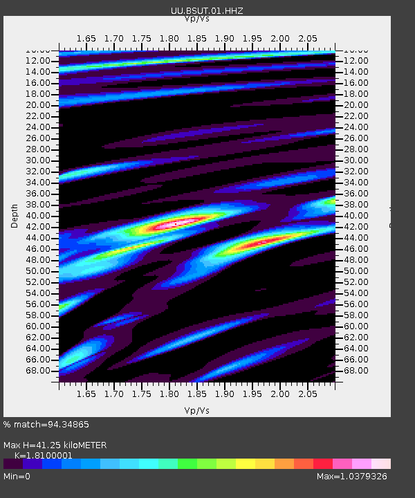
| Estimated Moho Depth: |
41.25 km |
| Estimated Crust Vp/Vs: |
1.81 |
| Assumed Crust Vp: |
6.155 km/s |
| Estimated Crust Vs: |
3.4 km/s |
| Estimated Crust Poisson's Ratio: |
0.28 |
|
| Radial Match: |
94.34865 % |
| Radial Bump: |
320 |
| Transverse Match: |
87.16077 % |
| Transverse Bump: |
400 |
| SOD ConfigId: |
1399611 |
| Insert Time: |
2016-02-07 11:11:44.210 +0000 |
| GWidth: |
2.5 |
| Max Bumps: |
400 |
| Tol: |
0.001 |
|

Signal To Noise
| Channel | StoN | STA | LTA |
| UU:BSUT:01:HHZ:20160124T10:36:19.447991Z | 3.9698508 | 8.400519E-8 | 2.1160792E-8 |
| UU:BSUT:01:HHN:20160124T10:36:19.447991Z | 4.516168 | 5.090153E-8 | 1.1270955E-8 |
| UU:BSUT:01:HHE:20160124T10:36:19.447991Z | 1.9476331 | 2.321538E-8 | 1.1919791E-8 |
| Arrivals |
| Ps | 5.8 SECOND |
| PpPs | 18 SECOND |
| PsPs/PpSs | 23 SECOND |


