You are here: Home > Network List > TA - USArray Transportable Network (new EarthScope stations) Stations List
> Station A18A Metzger Ranch, Havre, MT, USA > Earthquake Result Viewer
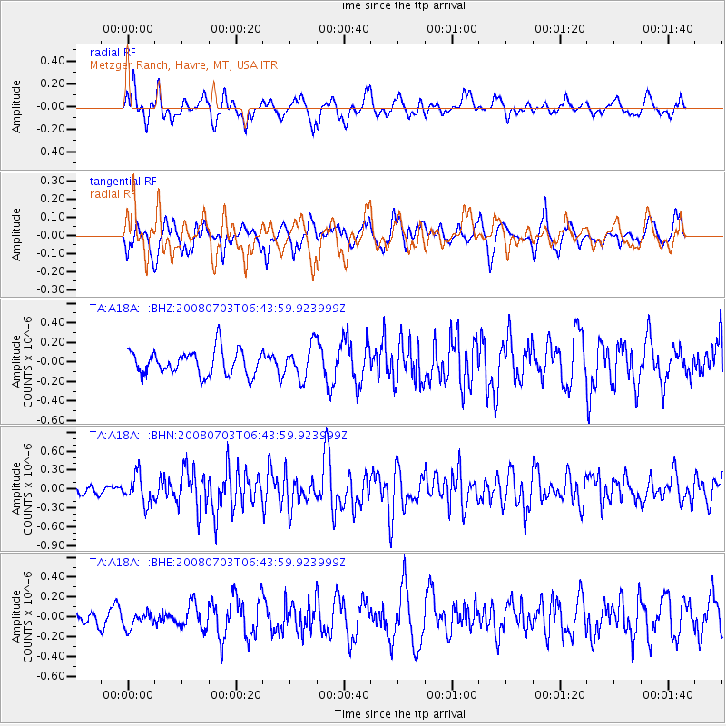
A18A Metzger Ranch, Havre, MT, USA - Earthquake Result Viewer
*The percent match for this event was below the threshold and hence no stack was calculated.
| Earthquake location: |
Trinidad |
| Earthquake latitude/longitude: |
10.3/-60.4 |
| Earthquake time(UTC): |
2008/07/03 (185) 06:34:53 GMT |
| Earthquake Depth: |
34 km |
| Earthquake Magnitude: |
5.7 MB, 5.5 MS, 5.8 MW, 5.7 MW |
| Earthquake Catalog/Contributor: |
WHDF/NEIC |
|
| Network: |
TA USArray Transportable Network (new EarthScope stations) |
| Station: |
A18A Metzger Ranch, Havre, MT, USA |
| Lat/Lon: |
48.92 N/109.85 W |
| Elevation: |
804 m |
|
| Distance: |
56.2 deg |
| Az: |
322.955 deg |
| Baz: |
115.993 deg |
| Ray Param: |
$rayparam |
*The percent match for this event was below the threshold and hence was not used in the summary stack. |
|
| Radial Match: |
68.71713 % |
| Radial Bump: |
400 |
| Transverse Match: |
55.427414 % |
| Transverse Bump: |
380 |
| SOD ConfigId: |
2504 |
| Insert Time: |
2010-03-06 02:43:11.504 +0000 |
| GWidth: |
2.5 |
| Max Bumps: |
400 |
| Tol: |
0.001 |
|
Signal To Noise
| Channel | StoN | STA | LTA |
| TA:A18A: :BHN:20080703T06:43:59.923999Z | 2.690234 | 2.2289332E-7 | 8.2852765E-8 |
| TA:A18A: :BHE:20080703T06:43:59.923999Z | 0.64653903 | 8.118422E-8 | 1.255674E-7 |
| TA:A18A: :BHZ:20080703T06:43:59.923999Z | 1.3304029 | 1.6726281E-7 | 1.2572343E-7 |
| Arrivals |
| Ps | |
| PpPs | |
| PsPs/PpSs | |


