You are here: Home > Network List > TA - USArray Transportable Network (new EarthScope stations) Stations List
> Station A18A Metzger Ranch, Havre, MT, USA > Earthquake Result Viewer
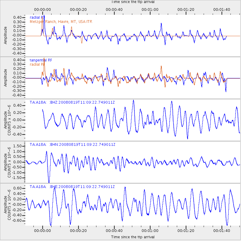
A18A Metzger Ranch, Havre, MT, USA - Earthquake Result Viewer
*The percent match for this event was below the threshold and hence no stack was calculated.
| Earthquake location: |
Easter Island Region |
| Earthquake latitude/longitude: |
-28.5/-112.8 |
| Earthquake time(UTC): |
2008/08/19 (232) 10:58:00 GMT |
| Earthquake Depth: |
9.0 km |
| Earthquake Magnitude: |
5.5 MB, 5.3 MS, 5.7 MW, 5.7 MW |
| Earthquake Catalog/Contributor: |
WHDF/NEIC |
|
| Network: |
TA USArray Transportable Network (new EarthScope stations) |
| Station: |
A18A Metzger Ranch, Havre, MT, USA |
| Lat/Lon: |
48.92 N/109.85 W |
| Elevation: |
804 m |
|
| Distance: |
77.2 deg |
| Az: |
2.026 deg |
| Baz: |
182.703 deg |
| Ray Param: |
$rayparam |
*The percent match for this event was below the threshold and hence was not used in the summary stack. |
|
| Radial Match: |
69.29543 % |
| Radial Bump: |
331 |
| Transverse Match: |
60.96381 % |
| Transverse Bump: |
348 |
| SOD ConfigId: |
2504 |
| Insert Time: |
2010-03-06 02:43:19.142 +0000 |
| GWidth: |
2.5 |
| Max Bumps: |
400 |
| Tol: |
0.001 |
|
Signal To Noise
| Channel | StoN | STA | LTA |
| TA:A18A: :BHN:20080819T11:09:22.749011Z | 10.217572 | 8.147502E-7 | 7.97401E-8 |
| TA:A18A: :BHE:20080819T11:09:22.749011Z | 1.3631061 | 2.8708186E-7 | 2.1060859E-7 |
| TA:A18A: :BHZ:20080819T11:09:22.749011Z | 1.4184564 | 1.8230823E-7 | 1.2852578E-7 |
| Arrivals |
| Ps | |
| PpPs | |
| PsPs/PpSs | |


