You are here: Home > Network List > TA - USArray Transportable Network (new EarthScope stations) Stations List
> Station A18A Metzger Ranch, Havre, MT, USA > Earthquake Result Viewer
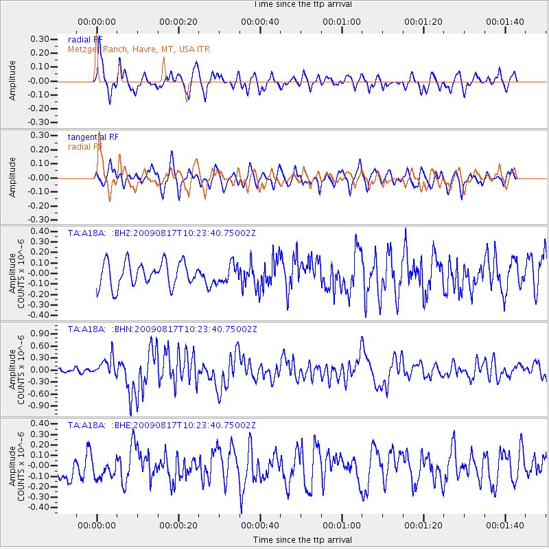
A18A Metzger Ranch, Havre, MT, USA - Earthquake Result Viewer
*The percent match for this event was below the threshold and hence no stack was calculated.
| Earthquake location: |
Southwestern Ryukyu Isl., Japan |
| Earthquake latitude/longitude: |
23.4/123.5 |
| Earthquake time(UTC): |
2009/08/17 (229) 10:10:55 GMT |
| Earthquake Depth: |
10 km |
| Earthquake Magnitude: |
5.9 MB, 6.2 MS, 6.1 MW, 6.1 MW |
| Earthquake Catalog/Contributor: |
WHDF/NEIC |
|
| Network: |
TA USArray Transportable Network (new EarthScope stations) |
| Station: |
A18A Metzger Ranch, Havre, MT, USA |
| Lat/Lon: |
48.92 N/109.85 W |
| Elevation: |
804 m |
|
| Distance: |
93.7 deg |
| Az: |
32.038 deg |
| Baz: |
312.378 deg |
| Ray Param: |
$rayparam |
*The percent match for this event was below the threshold and hence was not used in the summary stack. |
|
| Radial Match: |
66.98162 % |
| Radial Bump: |
380 |
| Transverse Match: |
52.183884 % |
| Transverse Bump: |
335 |
| SOD ConfigId: |
2622 |
| Insert Time: |
2010-03-06 02:43:34.147 +0000 |
| GWidth: |
2.5 |
| Max Bumps: |
400 |
| Tol: |
0.001 |
|
Signal To Noise
| Channel | StoN | STA | LTA |
| TA:A18A: :BHN:20090817T10:23:40.75002Z | 4.2256417 | 2.3462631E-7 | 5.5524424E-8 |
| TA:A18A: :BHE:20090817T10:23:40.75002Z | 0.5979724 | 8.298851E-8 | 1.3878318E-7 |
| TA:A18A: :BHZ:20090817T10:23:40.75002Z | 0.7572391 | 8.6943956E-8 | 1.1481704E-7 |
| Arrivals |
| Ps | |
| PpPs | |
| PsPs/PpSs | |


