You are here: Home > Network List > TA - USArray Transportable Network (new EarthScope stations) Stations List
> Station N23A Red Feather Lakes, CO, USA > Earthquake Result Viewer
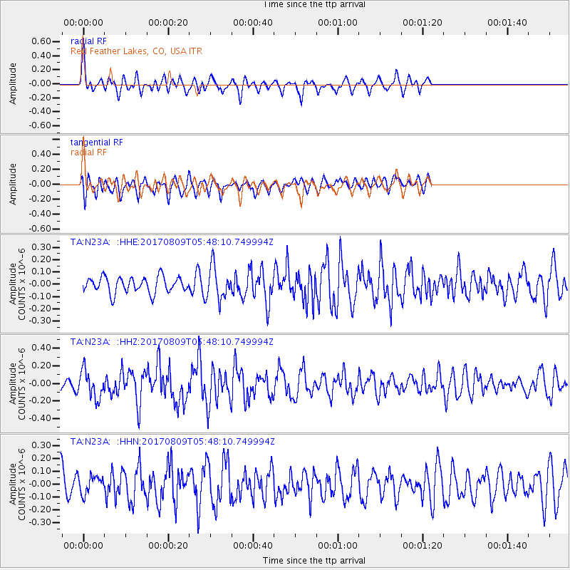
N23A Red Feather Lakes, CO, USA - Earthquake Result Viewer
*The percent match for this event was below the threshold and hence no stack was calculated.
| Earthquake location: |
Fox Islands, Aleutian Islands |
| Earthquake latitude/longitude: |
52.6/-169.2 |
| Earthquake time(UTC): |
2017/08/09 (221) 05:40:42 GMT |
| Earthquake Depth: |
47 km |
| Earthquake Magnitude: |
5.3 mb |
| Earthquake Catalog/Contributor: |
NEIC PDE/us |
|
| Network: |
TA USArray Transportable Network (new EarthScope stations) |
| Station: |
N23A Red Feather Lakes, CO, USA |
| Lat/Lon: |
40.89 N/105.94 W |
| Elevation: |
2458 m |
|
| Distance: |
43.5 deg |
| Az: |
79.312 deg |
| Baz: |
307.7 deg |
| Ray Param: |
$rayparam |
*The percent match for this event was below the threshold and hence was not used in the summary stack. |
|
| Radial Match: |
58.538654 % |
| Radial Bump: |
372 |
| Transverse Match: |
52.73466 % |
| Transverse Bump: |
400 |
| SOD ConfigId: |
13570011 |
| Insert Time: |
2019-04-28 13:49:12.362 +0000 |
| GWidth: |
2.5 |
| Max Bumps: |
400 |
| Tol: |
0.001 |
|
Signal To Noise
| Channel | StoN | STA | LTA |
| TA:N23A: :HHZ:20170809T05:48:10.749994Z | 2.8618064 | 1.5978051E-7 | 5.5832047E-8 |
| TA:N23A: :HHN:20170809T05:48:10.749994Z | 0.6354475 | 6.7998194E-8 | 1.0700836E-7 |
| TA:N23A: :HHE:20170809T05:48:10.749994Z | 2.073889 | 1.3394902E-7 | 6.458833E-8 |
| Arrivals |
| Ps | |
| PpPs | |
| PsPs/PpSs | |


