You are here: Home > Network List > WI - West Indies IPGP Network Stations List
> Station TDBA Terre de Bas, Les Saintes > Earthquake Result Viewer
TDBA Terre de Bas, Les Saintes - Earthquake Result Viewer
| Earthquake location: |
Southern Alaska |
| Earthquake latitude/longitude: |
59.7/-153.5 |
| Earthquake time(UTC): |
2016/01/24 (024) 10:30:30 GMT |
| Earthquake Depth: |
128 km |
| Earthquake Magnitude: |
7.1 MWW, 6.4 ML |
| Earthquake Catalog/Contributor: |
NEIC PDE/NEIC COMCAT |
|
| Network: |
WI West Indies IPGP Network |
| Station: |
TDBA Terre de Bas, Les Saintes |
| Lat/Lon: |
15.85 N/61.64 W |
| Elevation: |
176 m |
|
| Distance: |
77.4 deg |
| Az: |
80.317 deg |
| Baz: |
328.669 deg |
| Ray Param: |
0.050052043 |
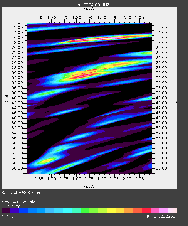
| Estimated Moho Depth: |
16.25 km |
| Estimated Crust Vp/Vs: |
1.89 |
| Assumed Crust Vp: |
5.88 km/s |
| Estimated Crust Vs: |
3.111 km/s |
| Estimated Crust Poisson's Ratio: |
0.31 |
|
| Radial Match: |
93.001564 % |
| Radial Bump: |
400 |
| Transverse Match: |
87.03097 % |
| Transverse Bump: |
400 |
| SOD ConfigId: |
1399611 |
| Insert Time: |
2016-02-07 11:13:41.644 +0000 |
| GWidth: |
2.5 |
| Max Bumps: |
400 |
| Tol: |
0.001 |
|

Signal To Noise
| Channel | StoN | STA | LTA |
| WI:TDBA:00:HHZ:20160124T10:41:39.929985Z | 2.4661534 | 1.8690135E-6 | 7.578659E-7 |
| WI:TDBA:00:HHN:20160124T10:41:39.929985Z | 1.0469627 | 1.0446693E-6 | 9.978094E-7 |
| WI:TDBA:00:HHE:20160124T10:41:39.929985Z | 1.440438 | 1.235947E-6 | 8.5803555E-7 |
| Arrivals |
| Ps | 2.5 SECOND |
| PpPs | 7.8 SECOND |
| PsPs/PpSs | 10 SECOND |


