You are here: Home > Network List > AK - Alaska Regional Network Stations List
> Station CUT Chulitna, AK, USA > Earthquake Result Viewer
CUT Chulitna, AK, USA - Earthquake Result Viewer
| Earthquake location: |
Luzon, Philippines |
| Earthquake latitude/longitude: |
14.0/120.7 |
| Earthquake time(UTC): |
2017/08/11 (223) 05:28:25 GMT |
| Earthquake Depth: |
168 km |
| Earthquake Magnitude: |
6.2 Mww |
| Earthquake Catalog/Contributor: |
NEIC PDE/us |
|
| Network: |
AK Alaska Regional Network |
| Station: |
CUT Chulitna, AK, USA |
| Lat/Lon: |
62.41 N/150.26 W |
| Elevation: |
574 m |
|
| Distance: |
77.3 deg |
| Az: |
28.511 deg |
| Baz: |
275.733 deg |
| Ray Param: |
0.050019395 |
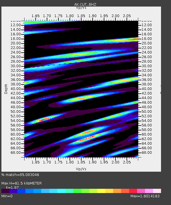
| Estimated Moho Depth: |
61.5 km |
| Estimated Crust Vp/Vs: |
1.87 |
| Assumed Crust Vp: |
6.438 km/s |
| Estimated Crust Vs: |
3.443 km/s |
| Estimated Crust Poisson's Ratio: |
0.30 |
|
| Radial Match: |
85.083046 % |
| Radial Bump: |
400 |
| Transverse Match: |
75.78322 % |
| Transverse Bump: |
400 |
| SOD ConfigId: |
13570011 |
| Insert Time: |
2019-04-28 13:51:23.730 +0000 |
| GWidth: |
2.5 |
| Max Bumps: |
400 |
| Tol: |
0.001 |
|
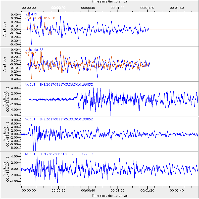
Signal To Noise
| Channel | StoN | STA | LTA |
| AK:CUT: :BHZ:20170811T05:39:30.019985Z | 19.848158 | 3.7989107E-6 | 1.9139866E-7 |
| AK:CUT: :BHN:20170811T05:39:30.019985Z | 6.053983 | 1.2001283E-6 | 1.982378E-7 |
| AK:CUT: :BHE:20170811T05:39:30.019985Z | 8.638321 | 1.4282679E-6 | 1.6534092E-7 |
| Arrivals |
| Ps | 8.6 SECOND |
| PpPs | 27 SECOND |
| PsPs/PpSs | 35 SECOND |


