You are here: Home > Network List > AK - Alaska Regional Network Stations List
> Station PWL Port Wells, AK, USA > Earthquake Result Viewer
PWL Port Wells, AK, USA - Earthquake Result Viewer
| Earthquake location: |
Luzon, Philippines |
| Earthquake latitude/longitude: |
14.0/120.7 |
| Earthquake time(UTC): |
2017/08/11 (223) 05:28:25 GMT |
| Earthquake Depth: |
168 km |
| Earthquake Magnitude: |
6.2 Mww |
| Earthquake Catalog/Contributor: |
NEIC PDE/us |
|
| Network: |
AK Alaska Regional Network |
| Station: |
PWL Port Wells, AK, USA |
| Lat/Lon: |
60.86 N/148.33 W |
| Elevation: |
555 m |
|
| Distance: |
78.4 deg |
| Az: |
29.978 deg |
| Baz: |
277.739 deg |
| Ray Param: |
0.049280886 |
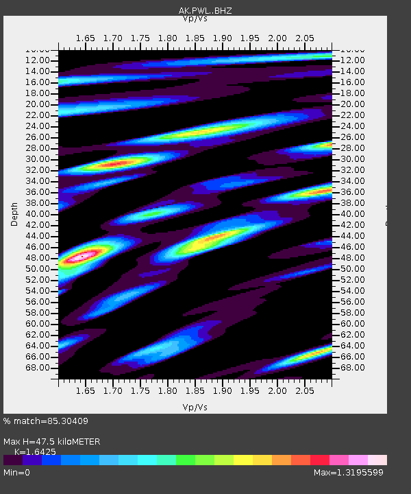
| Estimated Moho Depth: |
47.5 km |
| Estimated Crust Vp/Vs: |
1.64 |
| Assumed Crust Vp: |
6.566 km/s |
| Estimated Crust Vs: |
3.998 km/s |
| Estimated Crust Poisson's Ratio: |
0.21 |
|
| Radial Match: |
85.30409 % |
| Radial Bump: |
400 |
| Transverse Match: |
82.93933 % |
| Transverse Bump: |
400 |
| SOD ConfigId: |
13570011 |
| Insert Time: |
2019-04-28 13:51:55.425 +0000 |
| GWidth: |
2.5 |
| Max Bumps: |
400 |
| Tol: |
0.001 |
|

Signal To Noise
| Channel | StoN | STA | LTA |
| AK:PWL: :BHZ:20170811T05:39:36.048Z | 52.156517 | 3.4927077E-6 | 6.696589E-8 |
| AK:PWL: :BHN:20170811T05:39:36.048Z | 6.204789 | 7.0198297E-7 | 1.1313567E-7 |
| AK:PWL: :BHE:20170811T05:39:36.048Z | 9.014431 | 1.8525049E-6 | 2.0550435E-7 |
| Arrivals |
| Ps | 4.8 SECOND |
| PpPs | 18 SECOND |
| PsPs/PpSs | 23 SECOND |


