You are here: Home > Network List > CN - Canadian National Seismograph Network Stations List
> Station DIB DAWSON INLET, BC > Earthquake Result Viewer
DIB DAWSON INLET, BC - Earthquake Result Viewer
| Earthquake location: |
Luzon, Philippines |
| Earthquake latitude/longitude: |
14.0/120.7 |
| Earthquake time(UTC): |
2017/08/11 (223) 05:28:25 GMT |
| Earthquake Depth: |
168 km |
| Earthquake Magnitude: |
6.2 Mww |
| Earthquake Catalog/Contributor: |
NEIC PDE/us |
|
| Network: |
CN Canadian National Seismograph Network |
| Station: |
DIB DAWSON INLET, BC |
| Lat/Lon: |
53.20 N/132.48 W |
| Elevation: |
68 m |
|
| Distance: |
88.7 deg |
| Az: |
35.17 deg |
| Baz: |
291.658 deg |
| Ray Param: |
0.04203933 |
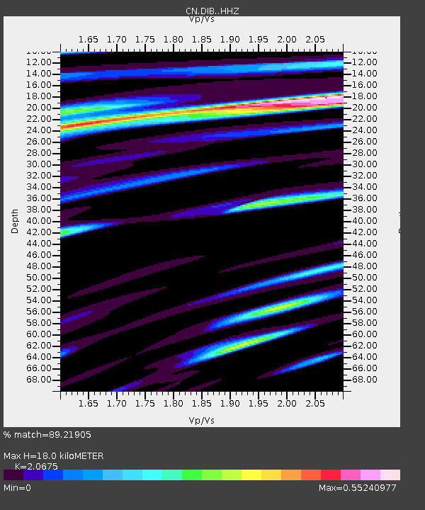
| Estimated Moho Depth: |
18.0 km |
| Estimated Crust Vp/Vs: |
2.07 |
| Assumed Crust Vp: |
6.183 km/s |
| Estimated Crust Vs: |
2.99 km/s |
| Estimated Crust Poisson's Ratio: |
0.35 |
|
| Radial Match: |
89.21905 % |
| Radial Bump: |
400 |
| Transverse Match: |
74.6214 % |
| Transverse Bump: |
400 |
| SOD ConfigId: |
13570011 |
| Insert Time: |
2019-04-28 13:53:33.169 +0000 |
| GWidth: |
2.5 |
| Max Bumps: |
400 |
| Tol: |
0.001 |
|

Signal To Noise
| Channel | StoN | STA | LTA |
| CN:DIB: :HHZ:20170811T05:40:28.319973Z | 10.466993 | 1.2196406E-6 | 1.16522536E-7 |
| CN:DIB: :HHN:20170811T05:40:28.319973Z | 1.7291484 | 1.4921677E-7 | 8.6294946E-8 |
| CN:DIB: :HHE:20170811T05:40:28.319973Z | 4.232812 | 3.2599624E-7 | 7.701647E-8 |
| Arrivals |
| Ps | 3.2 SECOND |
| PpPs | 8.8 SECOND |
| PsPs/PpSs | 12 SECOND |


