You are here: Home > Network List > GE - GEOFON Stations List
> Station SUMG GEOFON Station Summit Camp, Greenland > Earthquake Result Viewer
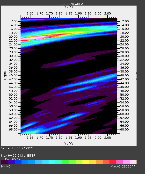
SUMG GEOFON Station Summit Camp, Greenland - Earthquake Result Viewer
| Earthquake location: |
Luzon, Philippines |
| Earthquake latitude/longitude: |
14.0/120.7 |
| Earthquake time(UTC): |
2017/08/11 (223) 05:28:25 GMT |
| Earthquake Depth: |
168 km |
| Earthquake Magnitude: |
6.2 Mww |
| Earthquake Catalog/Contributor: |
NEIC PDE/us |
|
| Network: |
GE GEOFON |
| Station: |
SUMG GEOFON Station Summit Camp, Greenland |
| Lat/Lon: |
72.57 N/38.46 W |
| Elevation: |
3200 m |
|
| Distance: |
92.5 deg |
| Az: |
353.844 deg |
| Baz: |
20.211 deg |
| Ray Param: |
0.041342996 |
| Estimated Moho Depth: |
20.5 km |
| Estimated Crust Vp/Vs: |
1.66 |
| Assumed Crust Vp: |
6.261 km/s |
| Estimated Crust Vs: |
3.777 km/s |
| Estimated Crust Poisson's Ratio: |
0.21 |
|
| Radial Match: |
88.247955 % |
| Radial Bump: |
400 |
| Transverse Match: |
65.59493 % |
| Transverse Bump: |
400 |
| SOD ConfigId: |
13570011 |
| Insert Time: |
2019-04-28 13:54:32.166 +0000 |
| GWidth: |
2.5 |
| Max Bumps: |
400 |
| Tol: |
0.001 |
|

Signal To Noise
| Channel | StoN | STA | LTA |
| GE:SUMG: :BHZ:20170811T05:40:46.04501Z | 18.386446 | 2.1587302E-6 | 1.1740878E-7 |
| GE:SUMG: :BHN:20170811T05:40:46.04501Z | 3.1209824 | 3.7211754E-7 | 1.192309E-7 |
| GE:SUMG: :BHE:20170811T05:40:46.04501Z | 1.7337922 | 2.1101498E-7 | 1.2170719E-7 |
| Arrivals |
| Ps | 2.2 SECOND |
| PpPs | 8.5 SECOND |
| PsPs/PpSs | 11 SECOND |


