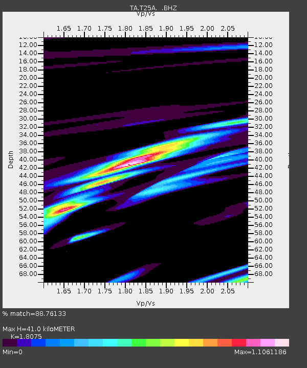
T25A Trinidad, CO, USA - Earthquake Result Viewer

Earthquake location: Rat Islands, Aleutian Islands
Earthquake latitude/longitude: 51.3/179.0
Earthquake time(UTC): 2008/07/25 (207) 00:29:22 GMT
Earthquake Depth: 21 km
Earthquake Magnitude: 5.7 MB, 5.5 MS, 5.9 MW, 5.9 MW
Earthquake Catalog/Contributor: WHDF/NEIC
Network: TA USArray Transportable Network (new EarthScope stations)
Station: T25A Trinidad, CO, USA
Lat/Lon: 37.14 N/104.41 W
Elevation: 2017 m
Distance: 54.3 deg
Az: 73.278 deg
Baz: 311.172 deg
Ray Param: 0.065530844
Estimated Moho Depth: 41.0 km
Estimated Crust Vp/Vs: 1.81
Assumed Crust Vp: 6.316 km/s
Estimated Crust Vs: 3.494 km/s
Estimated Crust Poisson's Ratio: 0.28
Radial Match: 88.76133 %
Radial Bump: 400
Transverse Match: 79.69845 %
Transverse Bump: 400
SOD ConfigId: 2504
Insert Time: 2010-03-06 02:45:01.784 +0000
GWidth: 2.5
Max Bumps: 400
Tol: 0.001

Signal To Noise

ChannelStoNSTALTA
TA:T25A: :BHZ:20080725T00:38:16.425017Z25.7977121.3110537E-65.082054E-8
TA:T25A: :BHN:20080725T00:38:16.425017Z7.6051744.0477826E-75.3224063E-8
TA:T25A: :BHE:20080725T00:38:16.425017Z5.3623623.1361685E-75.8484833E-8
Arrivals
Ps5.5 SECOND
PpPs17 SECOND
PsPs/PpSs23 SECOND