You are here: Home > Network List > MN - MEDNET Project Stations List
> Station VTS Vitosha, Bulgary > Earthquake Result Viewer
VTS Vitosha, Bulgary - Earthquake Result Viewer
| Earthquake location: |
Luzon, Philippines |
| Earthquake latitude/longitude: |
14.0/120.7 |
| Earthquake time(UTC): |
2017/08/11 (223) 05:28:25 GMT |
| Earthquake Depth: |
168 km |
| Earthquake Magnitude: |
6.2 Mww |
| Earthquake Catalog/Contributor: |
NEIC PDE/us |
|
| Network: |
MN MEDNET Project |
| Station: |
VTS Vitosha, Bulgary |
| Lat/Lon: |
42.62 N/23.24 E |
| Elevation: |
1490 m |
|
| Distance: |
86.0 deg |
| Az: |
312.809 deg |
| Baz: |
74.732 deg |
| Ray Param: |
0.043952808 |
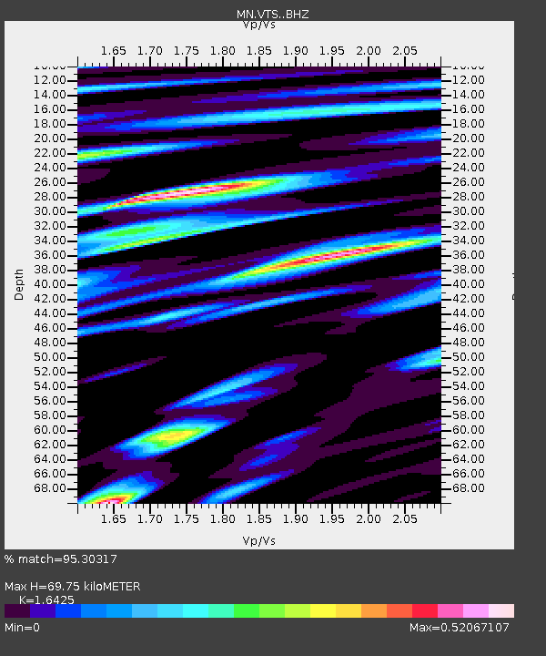
| Estimated Moho Depth: |
69.75 km |
| Estimated Crust Vp/Vs: |
1.64 |
| Assumed Crust Vp: |
6.291 km/s |
| Estimated Crust Vs: |
3.83 km/s |
| Estimated Crust Poisson's Ratio: |
0.21 |
|
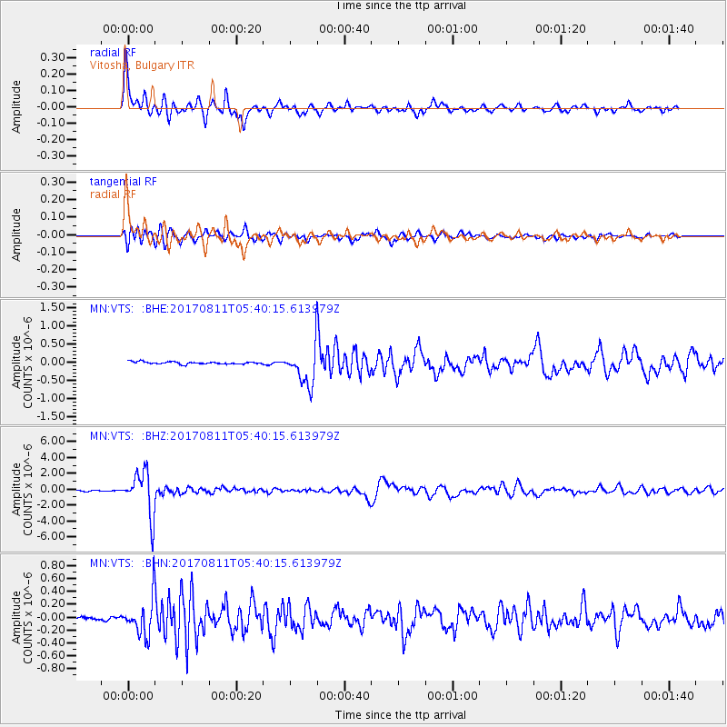
| Radial Match: |
95.30317 % |
| Radial Bump: |
380 |
| Transverse Match: |
88.05011 % |
| Transverse Bump: |
400 |
| SOD ConfigId: |
13570011 |
| Insert Time: |
2019-04-28 13:55:30.926 +0000 |
| GWidth: |
2.5 |
| Max Bumps: |
400 |
| Tol: |
0.001 |
|
Signal To Noise
| Channel | StoN | STA | LTA |
| MN:VTS: :BHZ:20170811T05:40:15.613979Z | 56.048634 | 2.815038E-6 | 5.0224916E-8 |
| MN:VTS: :BHN:20170811T05:40:15.613979Z | 13.319429 | 2.8977192E-7 | 2.175558E-8 |
| MN:VTS: :BHE:20170811T05:40:15.613979Z | 20.569803 | 6.4154517E-7 | 3.1188687E-8 |
| Arrivals |
| Ps | 7.3 SECOND |
| PpPs | 29 SECOND |
| PsPs/PpSs | 36 SECOND |


