You are here: Home > Network List > TA - USArray Transportable Network (new EarthScope stations) Stations List
> Station G23K Bananza Creek, AK, USA > Earthquake Result Viewer
G23K Bananza Creek, AK, USA - Earthquake Result Viewer
| Earthquake location: |
Luzon, Philippines |
| Earthquake latitude/longitude: |
14.0/120.7 |
| Earthquake time(UTC): |
2017/08/11 (223) 05:28:25 GMT |
| Earthquake Depth: |
168 km |
| Earthquake Magnitude: |
6.2 Mww |
| Earthquake Catalog/Contributor: |
NEIC PDE/us |
|
| Network: |
TA USArray Transportable Network (new EarthScope stations) |
| Station: |
G23K Bananza Creek, AK, USA |
| Lat/Lon: |
66.71 N/150.02 W |
| Elevation: |
746 m |
|
| Distance: |
77.0 deg |
| Az: |
24.086 deg |
| Baz: |
274.96 deg |
| Ray Param: |
0.05022193 |
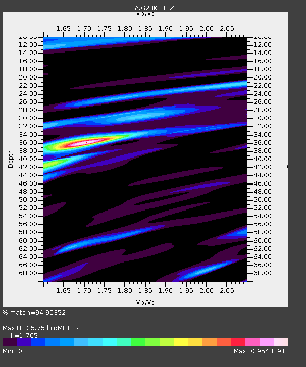
| Estimated Moho Depth: |
35.75 km |
| Estimated Crust Vp/Vs: |
1.71 |
| Assumed Crust Vp: |
6.577 km/s |
| Estimated Crust Vs: |
3.857 km/s |
| Estimated Crust Poisson's Ratio: |
0.24 |
|
| Radial Match: |
94.90352 % |
| Radial Bump: |
384 |
| Transverse Match: |
82.07475 % |
| Transverse Bump: |
400 |
| SOD ConfigId: |
13570011 |
| Insert Time: |
2019-04-28 13:56:45.326 +0000 |
| GWidth: |
2.5 |
| Max Bumps: |
400 |
| Tol: |
0.001 |
|
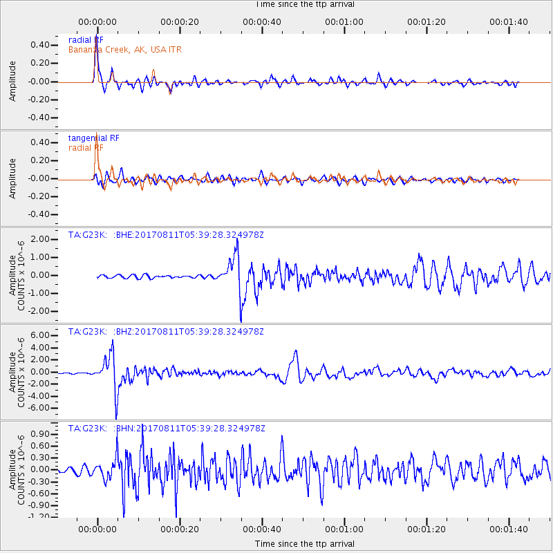
Signal To Noise
| Channel | StoN | STA | LTA |
| TA:G23K: :BHZ:20170811T05:39:28.324978Z | 49.4679 | 3.0062797E-6 | 6.077234E-8 |
| TA:G23K: :BHN:20170811T05:39:28.324978Z | 1.6443137 | 2.6725021E-7 | 1.6252994E-7 |
| TA:G23K: :BHE:20170811T05:39:28.324978Z | 12.810344 | 1.0369913E-6 | 8.094953E-8 |
| Arrivals |
| Ps | 4.0 SECOND |
| PpPs | 14 SECOND |
| PsPs/PpSs | 18 SECOND |


