You are here: Home > Network List > TA - USArray Transportable Network (new EarthScope stations) Stations List
> Station T25A Trinidad, CO, USA > Earthquake Result Viewer
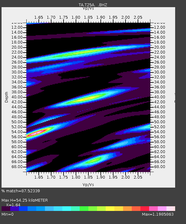
T25A Trinidad, CO, USA - Earthquake Result Viewer
| Earthquake location: |
Off Coast Of Costa Rica |
| Earthquake latitude/longitude: |
7.9/-85.6 |
| Earthquake time(UTC): |
2009/08/13 (225) 09:37:35 GMT |
| Earthquake Depth: |
10 km |
| Earthquake Magnitude: |
5.8 MW, 5.3 MB |
| Earthquake Catalog/Contributor: |
WHDF/NEIC |
|
| Network: |
TA USArray Transportable Network (new EarthScope stations) |
| Station: |
T25A Trinidad, CO, USA |
| Lat/Lon: |
37.14 N/104.41 W |
| Elevation: |
2017 m |
|
| Distance: |
33.7 deg |
| Az: |
332.376 deg |
| Baz: |
144.92 deg |
| Ray Param: |
0.07808887 |
| Estimated Moho Depth: |
54.25 km |
| Estimated Crust Vp/Vs: |
1.64 |
| Assumed Crust Vp: |
6.316 km/s |
| Estimated Crust Vs: |
3.851 km/s |
| Estimated Crust Poisson's Ratio: |
0.20 |
|
| Radial Match: |
87.52339 % |
| Radial Bump: |
297 |
| Transverse Match: |
70.38992 % |
| Transverse Bump: |
345 |
| SOD ConfigId: |
2622 |
| Insert Time: |
2010-03-06 02:45:35.699 +0000 |
| GWidth: |
2.5 |
| Max Bumps: |
400 |
| Tol: |
0.001 |
|

Signal To Noise
| Channel | StoN | STA | LTA |
| TA:T25A: :BHZ:20090813T09:43:45.774011Z | 4.6676664 | 3.097156E-7 | 6.6353415E-8 |
| TA:T25A: :BHN:20090813T09:43:45.774011Z | 4.6467896 | 1.9480807E-7 | 4.192315E-8 |
| TA:T25A: :BHE:20090813T09:43:45.774011Z | 4.4614096 | 1.8165171E-7 | 4.0716213E-8 |
| Arrivals |
| Ps | 6.0 SECOND |
| PpPs | 21 SECOND |
| PsPs/PpSs | 27 SECOND |


