You are here: Home > Network List > TA - USArray Transportable Network (new EarthScope stations) Stations List
> Station I27K Kandik River, AK, USA > Earthquake Result Viewer
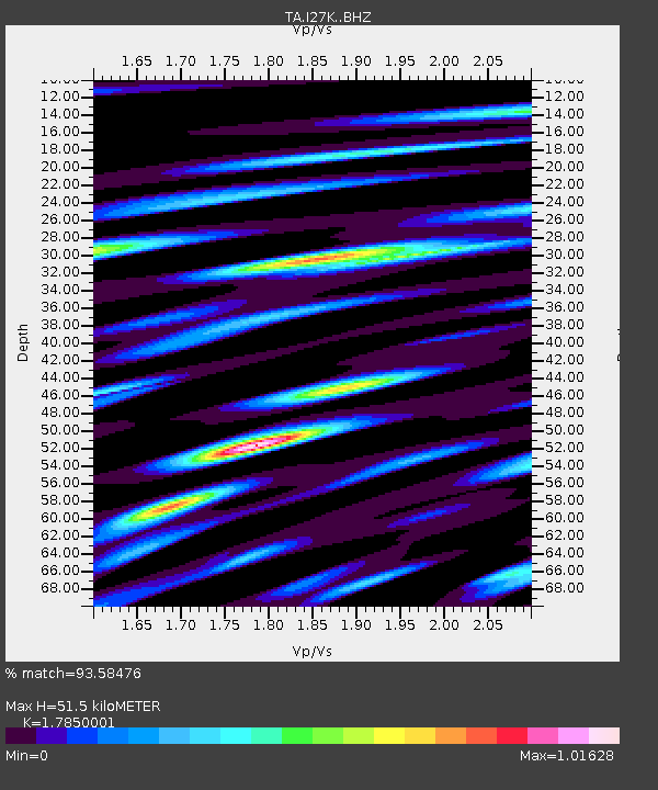
I27K Kandik River, AK, USA - Earthquake Result Viewer
| Earthquake location: |
Luzon, Philippines |
| Earthquake latitude/longitude: |
14.0/120.7 |
| Earthquake time(UTC): |
2017/08/11 (223) 05:28:25 GMT |
| Earthquake Depth: |
168 km |
| Earthquake Magnitude: |
6.2 Mww |
| Earthquake Catalog/Contributor: |
NEIC PDE/us |
|
| Network: |
TA USArray Transportable Network (new EarthScope stations) |
| Station: |
I27K Kandik River, AK, USA |
| Lat/Lon: |
65.60 N/141.62 W |
| Elevation: |
874 m |
|
| Distance: |
80.5 deg |
| Az: |
24.667 deg |
| Baz: |
282.759 deg |
| Ray Param: |
0.04782655 |
| Estimated Moho Depth: |
51.5 km |
| Estimated Crust Vp/Vs: |
1.79 |
| Assumed Crust Vp: |
6.566 km/s |
| Estimated Crust Vs: |
3.679 km/s |
| Estimated Crust Poisson's Ratio: |
0.27 |
|
| Radial Match: |
93.58476 % |
| Radial Bump: |
400 |
| Transverse Match: |
87.38769 % |
| Transverse Bump: |
400 |
| SOD ConfigId: |
13570011 |
| Insert Time: |
2019-04-28 13:57:03.358 +0000 |
| GWidth: |
2.5 |
| Max Bumps: |
400 |
| Tol: |
0.001 |
|

Signal To Noise
| Channel | StoN | STA | LTA |
| TA:I27K: :BHZ:20170811T05:39:47.600002Z | 47.6074 | 3.0471833E-6 | 6.400651E-8 |
| TA:I27K: :BHN:20170811T05:39:47.600002Z | 4.0507617 | 2.4088695E-7 | 5.9467077E-8 |
| TA:I27K: :BHE:20170811T05:39:47.600002Z | 27.077461 | 1.1087415E-6 | 4.0947025E-8 |
| Arrivals |
| Ps | 6.3 SECOND |
| PpPs | 21 SECOND |
| PsPs/PpSs | 28 SECOND |


