You are here: Home > Network List > TA - USArray Transportable Network (new EarthScope stations) Stations List
> Station K29M Barlow Dome, YT, CAN > Earthquake Result Viewer
K29M Barlow Dome, YT, CAN - Earthquake Result Viewer
| Earthquake location: |
Luzon, Philippines |
| Earthquake latitude/longitude: |
14.0/120.7 |
| Earthquake time(UTC): |
2017/08/11 (223) 05:28:25 GMT |
| Earthquake Depth: |
168 km |
| Earthquake Magnitude: |
6.2 Mww |
| Earthquake Catalog/Contributor: |
NEIC PDE/us |
|
| Network: |
TA USArray Transportable Network (new EarthScope stations) |
| Station: |
K29M Barlow Dome, YT, CAN |
| Lat/Lon: |
63.84 N/137.52 W |
| Elevation: |
1367 m |
|
| Distance: |
82.7 deg |
| Az: |
25.944 deg |
| Baz: |
286.645 deg |
| Ray Param: |
0.046340838 |
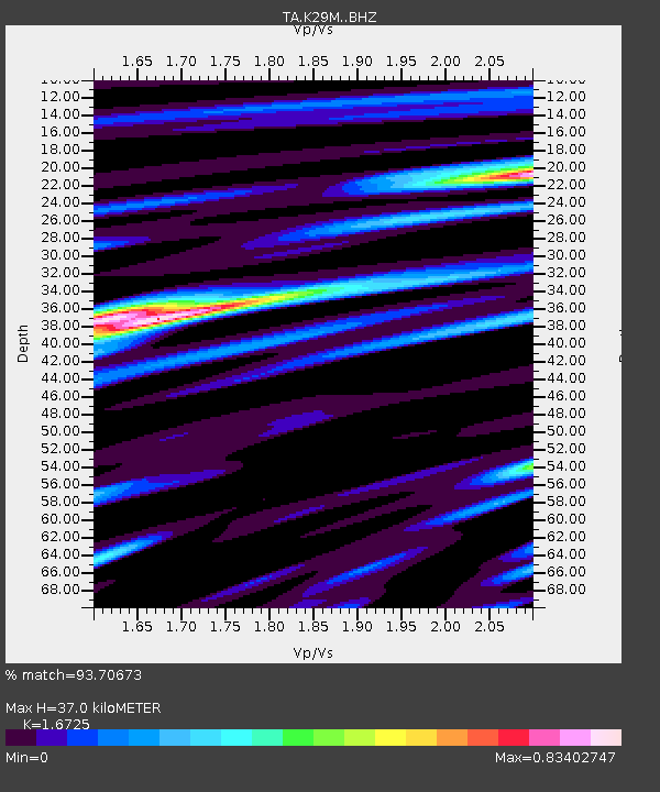
| Estimated Moho Depth: |
37.0 km |
| Estimated Crust Vp/Vs: |
1.67 |
| Assumed Crust Vp: |
6.566 km/s |
| Estimated Crust Vs: |
3.926 km/s |
| Estimated Crust Poisson's Ratio: |
0.22 |
|
| Radial Match: |
93.70673 % |
| Radial Bump: |
400 |
| Transverse Match: |
85.73407 % |
| Transverse Bump: |
400 |
| SOD ConfigId: |
13570011 |
| Insert Time: |
2019-04-28 13:57:19.534 +0000 |
| GWidth: |
2.5 |
| Max Bumps: |
400 |
| Tol: |
0.001 |
|
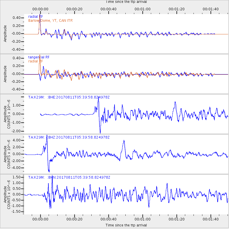
Signal To Noise
| Channel | StoN | STA | LTA |
| TA:K29M: :BHZ:20170811T05:39:58.824978Z | 55.35483 | 2.3191483E-6 | 4.1896044E-8 |
| TA:K29M: :BHN:20170811T05:39:58.824978Z | 7.2087355 | 2.9267005E-7 | 4.059936E-8 |
| TA:K29M: :BHE:20170811T05:39:58.824978Z | 17.82612 | 8.612298E-7 | 4.83128E-8 |
| Arrivals |
| Ps | 3.9 SECOND |
| PpPs | 15 SECOND |
| PsPs/PpSs | 19 SECOND |


