You are here: Home > Network List > TA - USArray Transportable Network (new EarthScope stations) Stations List
> Station V35K Ketchikan, AK, USA > Earthquake Result Viewer
V35K Ketchikan, AK, USA - Earthquake Result Viewer

| Earthquake location: |
Luzon, Philippines |
| Earthquake latitude/longitude: |
14.0/120.7 |
| Earthquake time(UTC): |
2017/08/11 (223) 05:28:25 GMT |
| Earthquake Depth: |
168 km |
| Earthquake Magnitude: |
6.2 Mww |
| Earthquake Catalog/Contributor: |
NEIC PDE/us |
|
| Network: |
TA USArray Transportable Network (new EarthScope stations) |
| Station: |
V35K Ketchikan, AK, USA |
| Lat/Lon: |
55.33 N/131.62 W |
| Elevation: |
64 m |
|
| Distance: |
88.3 deg |
| Az: |
33.005 deg |
| Baz: |
292.3 deg |
| Ray Param: |
0.042276684 |
| Estimated Moho Depth: |
33.25 km |
| Estimated Crust Vp/Vs: |
1.60 |
| Assumed Crust Vp: |
6.545 km/s |
| Estimated Crust Vs: |
4.091 km/s |
| Estimated Crust Poisson's Ratio: |
0.18 |
|
| Radial Match: |
84.32432 % |
| Radial Bump: |
400 |
| Transverse Match: |
80.07207 % |
| Transverse Bump: |
400 |
| SOD ConfigId: |
13570011 |
| Insert Time: |
2019-04-28 13:58:17.729 +0000 |
| GWidth: |
2.5 |
| Max Bumps: |
400 |
| Tol: |
0.001 |
|
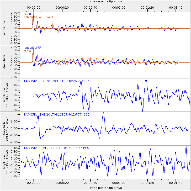
Signal To Noise
| Channel | StoN | STA | LTA |
| TA:V35K: :BHZ:20170811T05:40:26.77499Z | 11.602292 | 1.025106E-6 | 8.835375E-8 |
| TA:V35K: :BHN:20170811T05:40:26.77499Z | 1.8038108 | 1.0911876E-7 | 6.049346E-8 |
| TA:V35K: :BHE:20170811T05:40:26.77499Z | 3.4930944 | 3.2833526E-7 | 9.399553E-8 |
| Arrivals |
| Ps | 3.1 SECOND |
| PpPs | 13 SECOND |
| PsPs/PpSs | 16 SECOND |


