You are here: Home > Network List > WY - Yellowstone Wyoming Seismic Network Stations List
> Station YUF Upper Falls, WY, USA > Earthquake Result Viewer
YUF Upper Falls, WY, USA - Earthquake Result Viewer
| Earthquake location: |
Tonga Islands |
| Earthquake latitude/longitude: |
-19.6/-173.4 |
| Earthquake time(UTC): |
2016/01/25 (025) 00:00:09 GMT |
| Earthquake Depth: |
40 km |
| Earthquake Magnitude: |
5.7 MB |
| Earthquake Catalog/Contributor: |
NEIC PDE/NEIC COMCAT |
|
| Network: |
WY Yellowstone Wyoming Seismic Network |
| Station: |
YUF Upper Falls, WY, USA |
| Lat/Lon: |
44.71 N/110.51 W |
| Elevation: |
2394 m |
|
| Distance: |
85.8 deg |
| Az: |
39.519 deg |
| Baz: |
237.288 deg |
| Ray Param: |
0.04441903 |
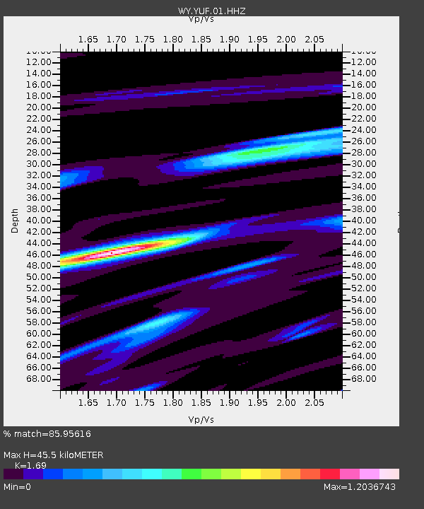
| Estimated Moho Depth: |
45.5 km |
| Estimated Crust Vp/Vs: |
1.69 |
| Assumed Crust Vp: |
6.35 km/s |
| Estimated Crust Vs: |
3.757 km/s |
| Estimated Crust Poisson's Ratio: |
0.23 |
|
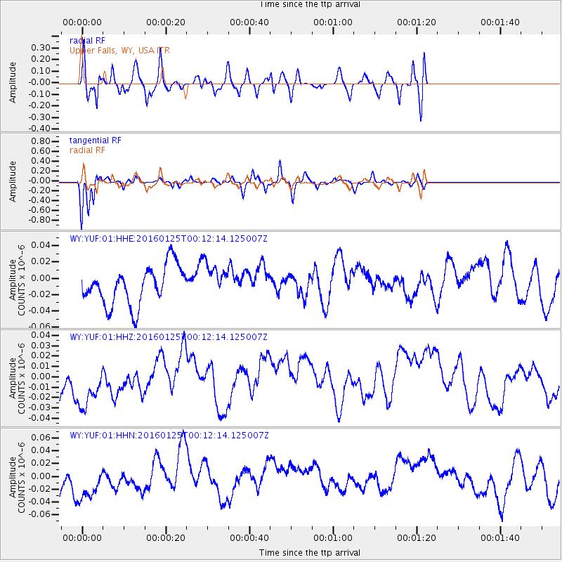
| Radial Match: |
85.95616 % |
| Radial Bump: |
400 |
| Transverse Match: |
87.05359 % |
| Transverse Bump: |
212 |
| SOD ConfigId: |
1399611 |
| Insert Time: |
2016-02-08 03:13:52.606 +0000 |
| GWidth: |
2.5 |
| Max Bumps: |
400 |
| Tol: |
0.001 |
|
Signal To Noise
| Channel | StoN | STA | LTA |
| WY:YUF:01:HHZ:20160125T00:12:14.125007Z | 1.2955953 | 3.289447E-8 | 2.5389463E-8 |
| WY:YUF:01:HHN:20160125T00:12:14.125007Z | 1.4553337 | 3.9209E-8 | 2.6941587E-8 |
| WY:YUF:01:HHE:20160125T00:12:14.125007Z | 0.91259587 | 2.1305201E-8 | 2.3345713E-8 |
| Arrivals |
| Ps | 5.1 SECOND |
| PpPs | 19 SECOND |
| PsPs/PpSs | 24 SECOND |


