You are here: Home > Network List > TA - USArray Transportable Network (new EarthScope stations) Stations List
> Station T25A Trinidad, CO, USA > Earthquake Result Viewer
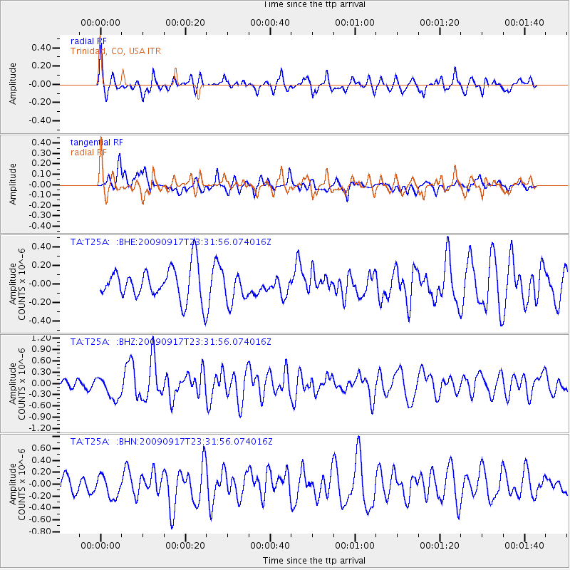
T25A Trinidad, CO, USA - Earthquake Result Viewer
*The percent match for this event was below the threshold and hence no stack was calculated.
| Earthquake location: |
Easter Island Region |
| Earthquake latitude/longitude: |
-29.1/-112.3 |
| Earthquake time(UTC): |
2009/09/17 (260) 23:21:38 GMT |
| Earthquake Depth: |
10 km |
| Earthquake Magnitude: |
5.7 MB, 6.0 MS, 6.2 MW, 6.2 MW |
| Earthquake Catalog/Contributor: |
WHDF/NEIC |
|
| Network: |
TA USArray Transportable Network (new EarthScope stations) |
| Station: |
T25A Trinidad, CO, USA |
| Lat/Lon: |
37.14 N/104.41 W |
| Elevation: |
2017 m |
|
| Distance: |
66.3 deg |
| Az: |
6.849 deg |
| Baz: |
187.501 deg |
| Ray Param: |
$rayparam |
*The percent match for this event was below the threshold and hence was not used in the summary stack. |
|
| Radial Match: |
70.30173 % |
| Radial Bump: |
400 |
| Transverse Match: |
54.87879 % |
| Transverse Bump: |
400 |
| SOD ConfigId: |
2622 |
| Insert Time: |
2010-03-06 02:46:51.271 +0000 |
| GWidth: |
2.5 |
| Max Bumps: |
400 |
| Tol: |
0.001 |
|
Signal To Noise
| Channel | StoN | STA | LTA |
| TA:T25A: :BHZ:20090917T23:31:56.074016Z | 2.0420222 | 3.0157153E-7 | 1.4768278E-7 |
| TA:T25A: :BHN:20090917T23:31:56.074016Z | 1.4831444 | 1.8336037E-7 | 1.2362948E-7 |
| TA:T25A: :BHE:20090917T23:31:56.074016Z | 0.92473036 | 1.6090887E-7 | 1.7400626E-7 |
| Arrivals |
| Ps | |
| PpPs | |
| PsPs/PpSs | |


