You are here: Home > Network List > TA - USArray Transportable Network (new EarthScope stations) Stations List
> Station T25A Trinidad, CO, USA > Earthquake Result Viewer
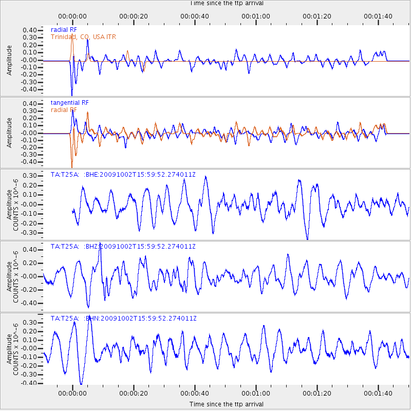
T25A Trinidad, CO, USA - Earthquake Result Viewer
*The percent match for this event was below the threshold and hence no stack was calculated.
| Earthquake location: |
Fiji Islands Region |
| Earthquake latitude/longitude: |
-17.0/174.5 |
| Earthquake time(UTC): |
2009/10/02 (275) 15:47:09 GMT |
| Earthquake Depth: |
10 km |
| Earthquake Magnitude: |
5.7 MB, 5.6 MS, 6.0 MW, 5.8 MW |
| Earthquake Catalog/Contributor: |
WHDF/NEIC |
|
| Network: |
TA USArray Transportable Network (new EarthScope stations) |
| Station: |
T25A Trinidad, CO, USA |
| Lat/Lon: |
37.14 N/104.41 W |
| Elevation: |
2017 m |
|
| Distance: |
93.2 deg |
| Az: |
52.253 deg |
| Baz: |
251.211 deg |
| Ray Param: |
$rayparam |
*The percent match for this event was below the threshold and hence was not used in the summary stack. |
|
| Radial Match: |
51.211933 % |
| Radial Bump: |
400 |
| Transverse Match: |
45.201305 % |
| Transverse Bump: |
400 |
| SOD ConfigId: |
2622 |
| Insert Time: |
2010-03-06 02:46:57.778 +0000 |
| GWidth: |
2.5 |
| Max Bumps: |
400 |
| Tol: |
0.001 |
|
Signal To Noise
| Channel | StoN | STA | LTA |
| TA:T25A: :BHZ:20091002T15:59:52.274011Z | 1.6345633 | 1.9596337E-7 | 1.1988729E-7 |
| TA:T25A: :BHN:20091002T15:59:52.274011Z | 2.726729 | 2.4214592E-7 | 8.880454E-8 |
| TA:T25A: :BHE:20091002T15:59:52.274011Z | 1.2566221 | 1.2967703E-7 | 1.03194935E-7 |
| Arrivals |
| Ps | |
| PpPs | |
| PsPs/PpSs | |


