You are here: Home > Network List > LD - Lamont-Doherty Cooperative Seismographic Network Stations List
> Station GEDE Greenville, DE, USA > Earthquake Result Viewer
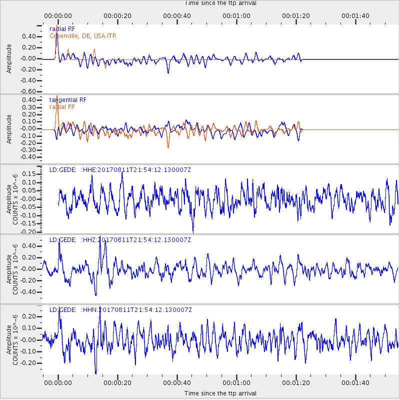
GEDE Greenville, DE, USA - Earthquake Result Viewer
*The percent match for this event was below the threshold and hence no stack was calculated.
| Earthquake location: |
Near Coast Of Peru |
| Earthquake latitude/longitude: |
-16.3/-73.5 |
| Earthquake time(UTC): |
2017/08/11 (223) 21:45:09 GMT |
| Earthquake Depth: |
35 km |
| Earthquake Magnitude: |
5.6 Mww |
| Earthquake Catalog/Contributor: |
NEIC PDE/us |
|
| Network: |
LD Lamont-Doherty Cooperative Seismographic Network |
| Station: |
GEDE Greenville, DE, USA |
| Lat/Lon: |
39.81 N/75.64 W |
| Elevation: |
105 m |
|
| Distance: |
55.9 deg |
| Az: |
357.993 deg |
| Baz: |
177.498 deg |
| Ray Param: |
$rayparam |
*The percent match for this event was below the threshold and hence was not used in the summary stack. |
|
| Radial Match: |
65.99037 % |
| Radial Bump: |
400 |
| Transverse Match: |
57.129627 % |
| Transverse Bump: |
400 |
| SOD ConfigId: |
13570011 |
| Insert Time: |
2019-04-28 14:03:00.586 +0000 |
| GWidth: |
2.5 |
| Max Bumps: |
400 |
| Tol: |
0.001 |
|
Signal To Noise
| Channel | StoN | STA | LTA |
| LD:GEDE: :HHZ:20170811T21:54:12.130007Z | 3.2703967 | 1.9209737E-7 | 5.8738248E-8 |
| LD:GEDE: :HHN:20170811T21:54:12.130007Z | 2.3655012 | 1.16107834E-7 | 4.9083823E-8 |
| LD:GEDE: :HHE:20170811T21:54:12.130007Z | 0.83931154 | 4.8093415E-8 | 5.7301033E-8 |
| Arrivals |
| Ps | |
| PpPs | |
| PsPs/PpSs | |


