You are here: Home > Network List > GS - US Geological Survey Networks Stations List
> Station OK031 2598 S. Brethren Rd., Cushing, OK, USA > Earthquake Result Viewer
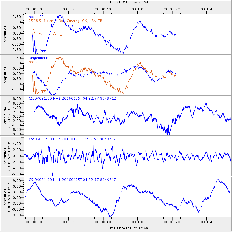
OK031 2598 S. Brethren Rd., Cushing, OK, USA - Earthquake Result Viewer
*The percent match for this event was below the threshold and hence no stack was calculated.
| Earthquake location: |
Strait Of Gibraltar |
| Earthquake latitude/longitude: |
35.7/-3.6 |
| Earthquake time(UTC): |
2016/01/25 (025) 04:22:02 GMT |
| Earthquake Depth: |
10 km |
| Earthquake Magnitude: |
6.1 MWP |
| Earthquake Catalog/Contributor: |
NEIC PDE/NEIC COMCAT |
|
| Network: |
GS US Geological Survey Networks |
| Station: |
OK031 2598 S. Brethren Rd., Cushing, OK, USA |
| Lat/Lon: |
35.95 N/96.84 W |
| Elevation: |
290 m |
|
| Distance: |
72.4 deg |
| Az: |
301.798 deg |
| Baz: |
58.449 deg |
| Ray Param: |
$rayparam |
*The percent match for this event was below the threshold and hence was not used in the summary stack. |
|
| Radial Match: |
39.523438 % |
| Radial Bump: |
400 |
| Transverse Match: |
43.342274 % |
| Transverse Bump: |
400 |
| SOD ConfigId: |
1399611 |
| Insert Time: |
2016-02-08 04:52:36.356 +0000 |
| GWidth: |
2.5 |
| Max Bumps: |
400 |
| Tol: |
0.001 |
|
Signal To Noise
| Channel | StoN | STA | LTA |
| GS:OK031:00:HHZ:20160125T04:32:57.804971Z | 3.9609165 | 1.1497762E-6 | 2.9028033E-7 |
| GS:OK031:00:HH1:20160125T04:32:57.804971Z | 6.2225227 | 7.815702E-6 | 1.2560344E-6 |
| GS:OK031:00:HH2:20160125T04:32:57.804971Z | 0.66436255 | 1.5938315E-6 | 2.3990387E-6 |
| Arrivals |
| Ps | |
| PpPs | |
| PsPs/PpSs | |


