You are here: Home > Network List > GS - US Geological Survey Networks Stations List
> Station DEC06 Boomer, Decatur, IL, USA > Earthquake Result Viewer
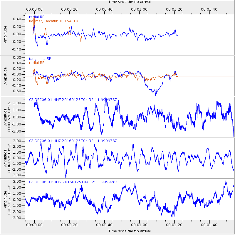
DEC06 Boomer, Decatur, IL, USA - Earthquake Result Viewer
*The percent match for this event was below the threshold and hence no stack was calculated.
| Earthquake location: |
Strait Of Gibraltar |
| Earthquake latitude/longitude: |
35.7/-3.6 |
| Earthquake time(UTC): |
2016/01/25 (025) 04:22:02 GMT |
| Earthquake Depth: |
10 km |
| Earthquake Magnitude: |
6.1 MWP |
| Earthquake Catalog/Contributor: |
NEIC PDE/NEIC COMCAT |
|
| Network: |
GS US Geological Survey Networks |
| Station: |
DEC06 Boomer, Decatur, IL, USA |
| Lat/Lon: |
39.90 N/88.95 W |
| Elevation: |
215 m |
|
| Distance: |
65.0 deg |
| Az: |
302.232 deg |
| Baz: |
63.445 deg |
| Ray Param: |
$rayparam |
*The percent match for this event was below the threshold and hence was not used in the summary stack. |
|
| Radial Match: |
74.4044 % |
| Radial Bump: |
400 |
| Transverse Match: |
25.874681 % |
| Transverse Bump: |
400 |
| SOD ConfigId: |
1399611 |
| Insert Time: |
2016-02-08 04:52:44.720 +0000 |
| GWidth: |
2.5 |
| Max Bumps: |
400 |
| Tol: |
0.001 |
|
Signal To Noise
| Channel | StoN | STA | LTA |
| GS:DEC06:01:HHZ:20160125T04:32:11.999978Z | 3.1985767 | 1.2054157E-6 | 3.7686004E-7 |
| GS:DEC06:01:HHN:20160125T04:32:11.999978Z | 0.35247356 | 3.763611E-7 | 1.0677712E-6 |
| GS:DEC06:01:HHE:20160125T04:32:11.999978Z | 1.4551897 | 1.1378585E-6 | 7.8193136E-7 |
| Arrivals |
| Ps | |
| PpPs | |
| PsPs/PpSs | |


