You are here: Home > Network List > GS - US Geological Survey Networks Stations List
> Station KAN13 Rinehart Farm, , CA, USA > Earthquake Result Viewer
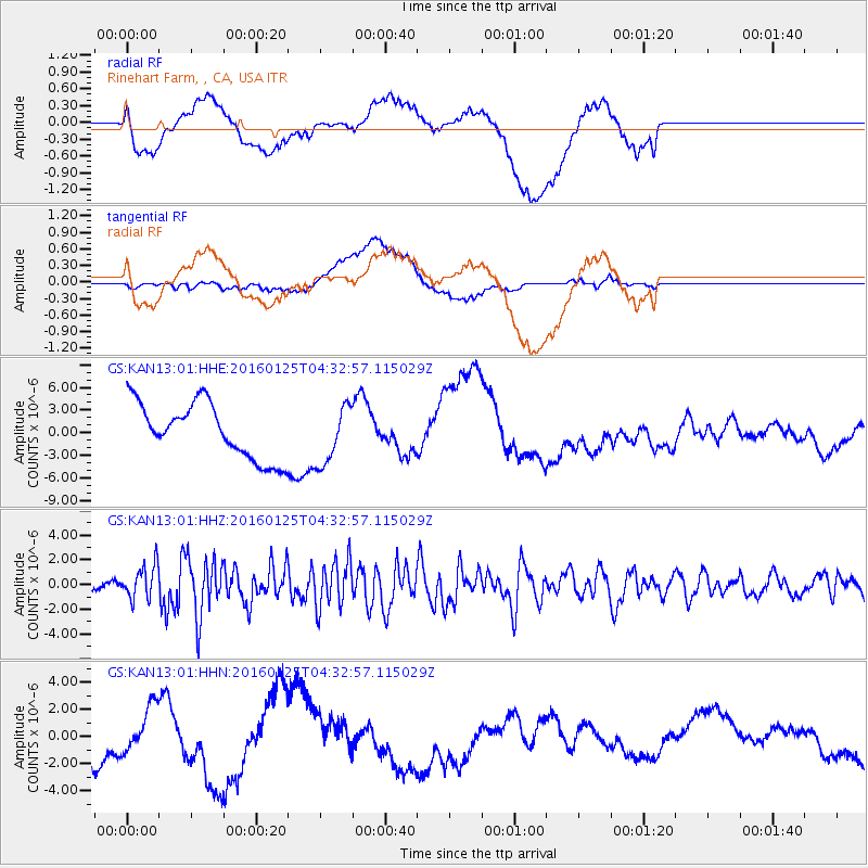
KAN13 Rinehart Farm, , CA, USA - Earthquake Result Viewer
*The percent match for this event was below the threshold and hence no stack was calculated.
| Earthquake location: |
Strait Of Gibraltar |
| Earthquake latitude/longitude: |
35.7/-3.6 |
| Earthquake time(UTC): |
2016/01/25 (025) 04:22:02 GMT |
| Earthquake Depth: |
10 km |
| Earthquake Magnitude: |
6.1 MWP |
| Earthquake Catalog/Contributor: |
NEIC PDE/NEIC COMCAT |
|
| Network: |
GS US Geological Survey Networks |
| Station: |
KAN13 Rinehart Farm, , CA, USA |
| Lat/Lon: |
37.01 N/97.48 W |
| Elevation: |
340 m |
|
| Distance: |
72.3 deg |
| Az: |
303.026 deg |
| Baz: |
58.444 deg |
| Ray Param: |
$rayparam |
*The percent match for this event was below the threshold and hence was not used in the summary stack. |
|
| Radial Match: |
26.194363 % |
| Radial Bump: |
400 |
| Transverse Match: |
28.105179 % |
| Transverse Bump: |
400 |
| SOD ConfigId: |
1399611 |
| Insert Time: |
2016-02-08 04:53:15.110 +0000 |
| GWidth: |
2.5 |
| Max Bumps: |
400 |
| Tol: |
0.001 |
|
Signal To Noise
| Channel | StoN | STA | LTA |
| GS:KAN13:01:HHZ:20160125T04:32:57.115029Z | 3.1080108 | 1.3698539E-6 | 4.4074937E-7 |
| GS:KAN13:01:HHN:20160125T04:32:57.115029Z | 1.3877797 | 1.7609594E-6 | 1.268904E-6 |
| GS:KAN13:01:HHE:20160125T04:32:57.115029Z | 1.0595368 | 3.865916E-6 | 3.6486845E-6 |
| Arrivals |
| Ps | |
| PpPs | |
| PsPs/PpSs | |


