You are here: Home > Network List > TA - USArray Transportable Network (new EarthScope stations) Stations List
> Station 226A Malaga, Loving, NM, USA > Earthquake Result Viewer
226A Malaga, Loving, NM, USA - Earthquake Result Viewer
| Earthquake location: |
Loyalty Islands |
| Earthquake latitude/longitude: |
-20.1/168.9 |
| Earthquake time(UTC): |
2008/04/09 (100) 12:46:12 GMT |
| Earthquake Depth: |
33 km |
| Earthquake Magnitude: |
6.3 MB, 7.3 MS, 7.3 MW, 7.3 MW |
| Earthquake Catalog/Contributor: |
WHDF/NEIC |
|
| Network: |
TA USArray Transportable Network (new EarthScope stations) |
| Station: |
226A Malaga, Loving, NM, USA |
| Lat/Lon: |
32.06 N/104.10 W |
| Elevation: |
929 m |
|
| Distance: |
98.0 deg |
| Az: |
58.889 deg |
| Baz: |
251.417 deg |
| Ray Param: |
0.0400353 |
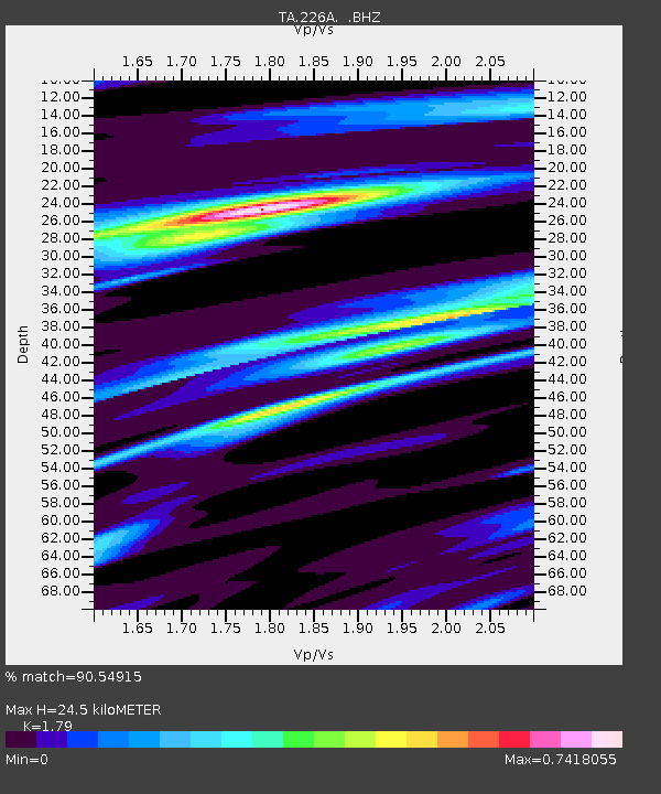
| Estimated Moho Depth: |
24.5 km |
| Estimated Crust Vp/Vs: |
1.79 |
| Assumed Crust Vp: |
6.232 km/s |
| Estimated Crust Vs: |
3.481 km/s |
| Estimated Crust Poisson's Ratio: |
0.27 |
|
| Radial Match: |
90.54915 % |
| Radial Bump: |
336 |
| Transverse Match: |
78.314415 % |
| Transverse Bump: |
283 |
| SOD ConfigId: |
2504 |
| Insert Time: |
2010-03-06 02:47:40.585 +0000 |
| GWidth: |
2.5 |
| Max Bumps: |
400 |
| Tol: |
0.001 |
|

Signal To Noise
| Channel | StoN | STA | LTA |
| TA:226A: :BHZ:20080409T12:59:13.850005Z | 2.511507 | 1.0112191E-6 | 4.0263436E-7 |
| TA:226A: :BHN:20080409T12:59:13.850005Z | 0.31608763 | 8.302589E-8 | 2.6266733E-7 |
| TA:226A: :BHE:20080409T12:59:13.850005Z | 1.2063999 | 2.2388882E-7 | 1.8558424E-7 |
| Arrivals |
| Ps | 3.2 SECOND |
| PpPs | 11 SECOND |
| PsPs/PpSs | 14 SECOND |


