You are here: Home > Network List > TA - USArray Transportable Network (new EarthScope stations) Stations List
> Station 226A Malaga, Loving, NM, USA > Earthquake Result Viewer
226A Malaga, Loving, NM, USA - Earthquake Result Viewer
| Earthquake location: |
Andreanof Islands, Aleutian Is. |
| Earthquake latitude/longitude: |
51.9/-179.2 |
| Earthquake time(UTC): |
2008/04/16 (107) 05:54:19 GMT |
| Earthquake Depth: |
13 km |
| Earthquake Magnitude: |
6.1 MB, 6.5 MS, 6.6 MW, 6.6 MW |
| Earthquake Catalog/Contributor: |
WHDF/NEIC |
|
| Network: |
TA USArray Transportable Network (new EarthScope stations) |
| Station: |
226A Malaga, Loving, NM, USA |
| Lat/Lon: |
32.06 N/104.10 W |
| Elevation: |
929 m |
|
| Distance: |
56.6 deg |
| Az: |
79.25 deg |
| Baz: |
314.17 deg |
| Ray Param: |
0.064016 |
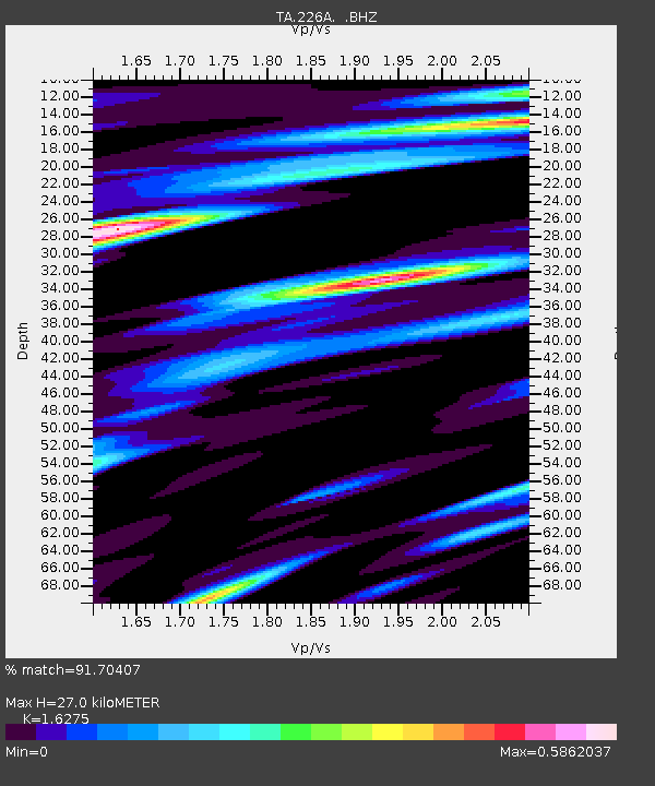
| Estimated Moho Depth: |
27.0 km |
| Estimated Crust Vp/Vs: |
1.63 |
| Assumed Crust Vp: |
6.232 km/s |
| Estimated Crust Vs: |
3.829 km/s |
| Estimated Crust Poisson's Ratio: |
0.20 |
|
| Radial Match: |
91.70407 % |
| Radial Bump: |
400 |
| Transverse Match: |
83.37744 % |
| Transverse Bump: |
400 |
| SOD ConfigId: |
2504 |
| Insert Time: |
2010-03-06 02:47:43.932 +0000 |
| GWidth: |
2.5 |
| Max Bumps: |
400 |
| Tol: |
0.001 |
|

Signal To Noise
| Channel | StoN | STA | LTA |
| TA:226A: :BHZ:20080416T06:03:31.20001Z | 3.2423704 | 8.72953E-7 | 2.6923297E-7 |
| TA:226A: :BHN:20080416T06:03:31.20001Z | 2.1108398 | 2.1502615E-7 | 1.0186758E-7 |
| TA:226A: :BHE:20080416T06:03:31.20001Z | 3.3081017 | 2.2099205E-7 | 6.680328E-8 |
| Arrivals |
| Ps | 2.9 SECOND |
| PpPs | 11 SECOND |
| PsPs/PpSs | 14 SECOND |


