You are here: Home > Network List > TA - USArray Transportable Network (new EarthScope stations) Stations List
> Station MSTX Muleshoe, TX, USA > Earthquake Result Viewer
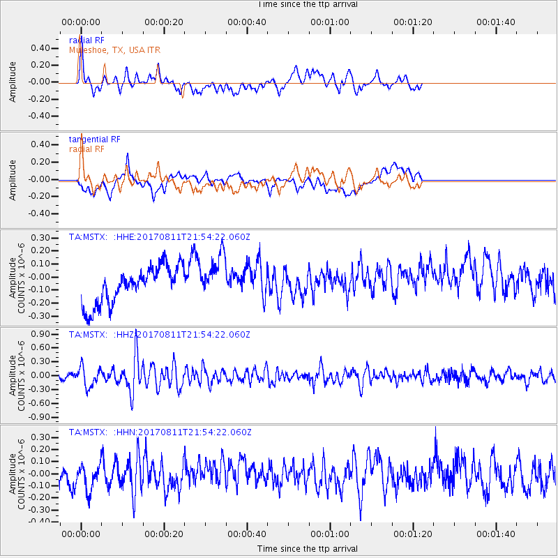
MSTX Muleshoe, TX, USA - Earthquake Result Viewer
*The percent match for this event was below the threshold and hence no stack was calculated.
| Earthquake location: |
Near Coast Of Peru |
| Earthquake latitude/longitude: |
-16.3/-73.5 |
| Earthquake time(UTC): |
2017/08/11 (223) 21:45:09 GMT |
| Earthquake Depth: |
35 km |
| Earthquake Magnitude: |
5.6 Mww |
| Earthquake Catalog/Contributor: |
NEIC PDE/us |
|
| Network: |
TA USArray Transportable Network (new EarthScope stations) |
| Station: |
MSTX Muleshoe, TX, USA |
| Lat/Lon: |
33.97 N/102.77 W |
| Elevation: |
1167 m |
|
| Distance: |
57.3 deg |
| Az: |
331.09 deg |
| Baz: |
146.041 deg |
| Ray Param: |
$rayparam |
*The percent match for this event was below the threshold and hence was not used in the summary stack. |
|
| Radial Match: |
58.519825 % |
| Radial Bump: |
400 |
| Transverse Match: |
37.821125 % |
| Transverse Bump: |
400 |
| SOD ConfigId: |
13570011 |
| Insert Time: |
2019-04-28 14:06:48.452 +0000 |
| GWidth: |
2.5 |
| Max Bumps: |
400 |
| Tol: |
0.001 |
|
Signal To Noise
| Channel | StoN | STA | LTA |
| TA:MSTX: :HHZ:20170811T21:54:22.060Z | 3.3522954 | 2.174733E-7 | 6.487295E-8 |
| TA:MSTX: :HHN:20170811T21:54:22.060Z | 1.9932214 | 1.0908164E-7 | 5.4726303E-8 |
| TA:MSTX: :HHE:20170811T21:54:22.060Z | 1.2470968 | 1.7414864E-7 | 1.3964325E-7 |
| Arrivals |
| Ps | |
| PpPs | |
| PsPs/PpSs | |


