You are here: Home > Network List > TA - USArray Transportable Network (new EarthScope stations) Stations List
> Station R33M Jennings River, BC, CAN > Earthquake Result Viewer
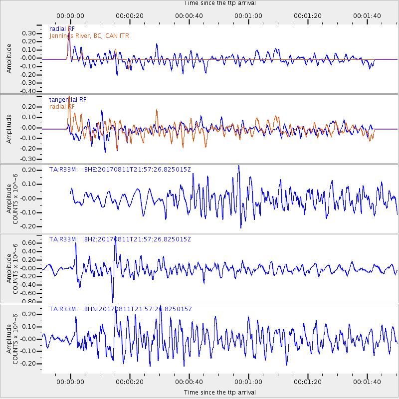
R33M Jennings River, BC, CAN - Earthquake Result Viewer
*The percent match for this event was below the threshold and hence no stack was calculated.
| Earthquake location: |
Near Coast Of Peru |
| Earthquake latitude/longitude: |
-16.3/-73.5 |
| Earthquake time(UTC): |
2017/08/11 (223) 21:45:09 GMT |
| Earthquake Depth: |
35 km |
| Earthquake Magnitude: |
5.6 Mww |
| Earthquake Catalog/Contributor: |
NEIC PDE/us |
|
| Network: |
TA USArray Transportable Network (new EarthScope stations) |
| Station: |
R33M Jennings River, BC, CAN |
| Lat/Lon: |
59.39 N/130.97 W |
| Elevation: |
1437 m |
|
| Distance: |
88.6 deg |
| Az: |
334.431 deg |
| Baz: |
125.901 deg |
| Ray Param: |
$rayparam |
*The percent match for this event was below the threshold and hence was not used in the summary stack. |
|
| Radial Match: |
69.52781 % |
| Radial Bump: |
400 |
| Transverse Match: |
71.27148 % |
| Transverse Bump: |
400 |
| SOD ConfigId: |
13570011 |
| Insert Time: |
2019-04-28 14:06:58.956 +0000 |
| GWidth: |
2.5 |
| Max Bumps: |
400 |
| Tol: |
0.001 |
|
Signal To Noise
| Channel | StoN | STA | LTA |
| TA:R33M: :BHZ:20170811T21:57:26.825015Z | 3.9909074 | 2.2912495E-7 | 5.7411743E-8 |
| TA:R33M: :BHN:20170811T21:57:26.825015Z | 2.588752 | 6.107946E-8 | 2.359417E-8 |
| TA:R33M: :BHE:20170811T21:57:26.825015Z | 1.1602991 | 4.7787275E-8 | 4.118531E-8 |
| Arrivals |
| Ps | |
| PpPs | |
| PsPs/PpSs | |


