You are here: Home > Network List > TA - USArray Transportable Network (new EarthScope stations) Stations List
> Station TPFO Pinon Flats, CA, USA > Earthquake Result Viewer
TPFO Pinon Flats, CA, USA - Earthquake Result Viewer
*The percent match for this event was below the threshold and hence no stack was calculated.
| Earthquake location: |
Near Coast Of Peru |
| Earthquake latitude/longitude: |
-16.3/-73.5 |
| Earthquake time(UTC): |
2017/08/11 (223) 21:45:09 GMT |
| Earthquake Depth: |
35 km |
| Earthquake Magnitude: |
5.6 Mww |
| Earthquake Catalog/Contributor: |
NEIC PDE/us |
|
| Network: |
TA USArray Transportable Network (new EarthScope stations) |
| Station: |
TPFO Pinon Flats, CA, USA |
| Lat/Lon: |
33.61 N/116.45 W |
| Elevation: |
1275 m |
|
| Distance: |
64.4 deg |
| Az: |
320.874 deg |
| Baz: |
133.44 deg |
| Ray Param: |
$rayparam |
*The percent match for this event was below the threshold and hence was not used in the summary stack. |
|
| Radial Match: |
48.222786 % |
| Radial Bump: |
400 |
| Transverse Match: |
48.89574 % |
| Transverse Bump: |
400 |
| SOD ConfigId: |
13570011 |
| Insert Time: |
2019-04-28 14:07:06.041 +0000 |
| GWidth: |
2.5 |
| Max Bumps: |
400 |
| Tol: |
0.001 |
|
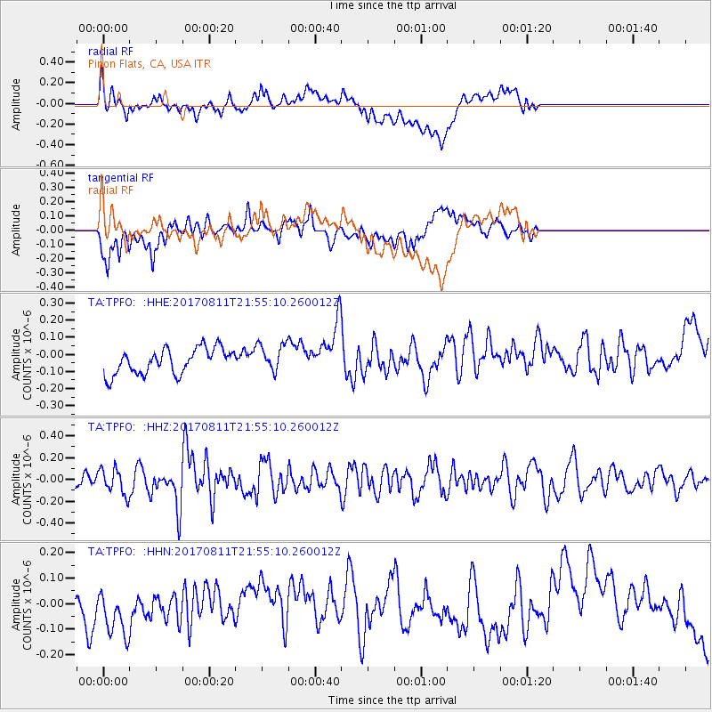
Signal To Noise
| Channel | StoN | STA | LTA |
| TA:TPFO: :HHZ:20170811T21:55:10.260012Z | 2.3588815 | 1.1976918E-7 | 5.077372E-8 |
| TA:TPFO: :HHN:20170811T21:55:10.260012Z | 1.8530954 | 1.1962297E-7 | 6.4553056E-8 |
| TA:TPFO: :HHE:20170811T21:55:10.260012Z | 1.1533824 | 8.49695E-8 | 7.366984E-8 |
| Arrivals |
| Ps | |
| PpPs | |
| PsPs/PpSs | |


