You are here: Home > Network List > TA - USArray Transportable Network (new EarthScope stations) Stations List
> Station 226A Malaga, Loving, NM, USA > Earthquake Result Viewer
226A Malaga, Loving, NM, USA - Earthquake Result Viewer
| Earthquake location: |
Santa Cruz Islands Region |
| Earthquake latitude/longitude: |
-11.1/164.6 |
| Earthquake time(UTC): |
2008/07/19 (201) 11:01:17 GMT |
| Earthquake Depth: |
10 km |
| Earthquake Magnitude: |
5.8 MB, 5.9 MS, 6.2 MW, 6.2 MW |
| Earthquake Catalog/Contributor: |
WHDF/NEIC |
|
| Network: |
TA USArray Transportable Network (new EarthScope stations) |
| Station: |
226A Malaga, Loving, NM, USA |
| Lat/Lon: |
32.06 N/104.10 W |
| Elevation: |
929 m |
|
| Distance: |
96.9 deg |
| Az: |
58.757 deg |
| Baz: |
261.292 deg |
| Ray Param: |
0.040389337 |
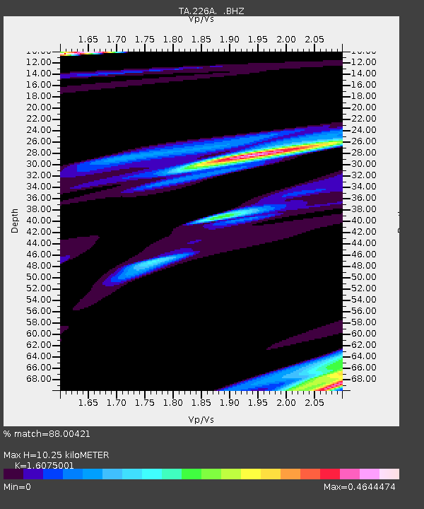
| Estimated Moho Depth: |
10.25 km |
| Estimated Crust Vp/Vs: |
1.61 |
| Assumed Crust Vp: |
6.232 km/s |
| Estimated Crust Vs: |
3.877 km/s |
| Estimated Crust Poisson's Ratio: |
0.18 |
|
| Radial Match: |
88.00421 % |
| Radial Bump: |
400 |
| Transverse Match: |
55.35419 % |
| Transverse Bump: |
400 |
| SOD ConfigId: |
2504 |
| Insert Time: |
2010-03-06 02:47:52.895 +0000 |
| GWidth: |
2.5 |
| Max Bumps: |
400 |
| Tol: |
0.001 |
|

Signal To Noise
| Channel | StoN | STA | LTA |
| TA:226A: :BHZ:20080719T11:14:17.074014Z | 1.6005069 | 7.931211E-7 | 4.9554365E-7 |
| TA:226A: :BHN:20080719T11:14:17.074014Z | 1.5318574 | 2.5656493E-7 | 1.6748618E-7 |
| TA:226A: :BHE:20080719T11:14:17.074014Z | 1.0952592 | 4.5244371E-7 | 4.1309283E-7 |
| Arrivals |
| Ps | 1.0 SECOND |
| PpPs | 4.2 SECOND |
| PsPs/PpSs | 5.2 SECOND |


