You are here: Home > Network List > UW - Pacific Northwest Regional Seismic Network Stations List
> Station LEBA Lebam, WA, USA > Earthquake Result Viewer
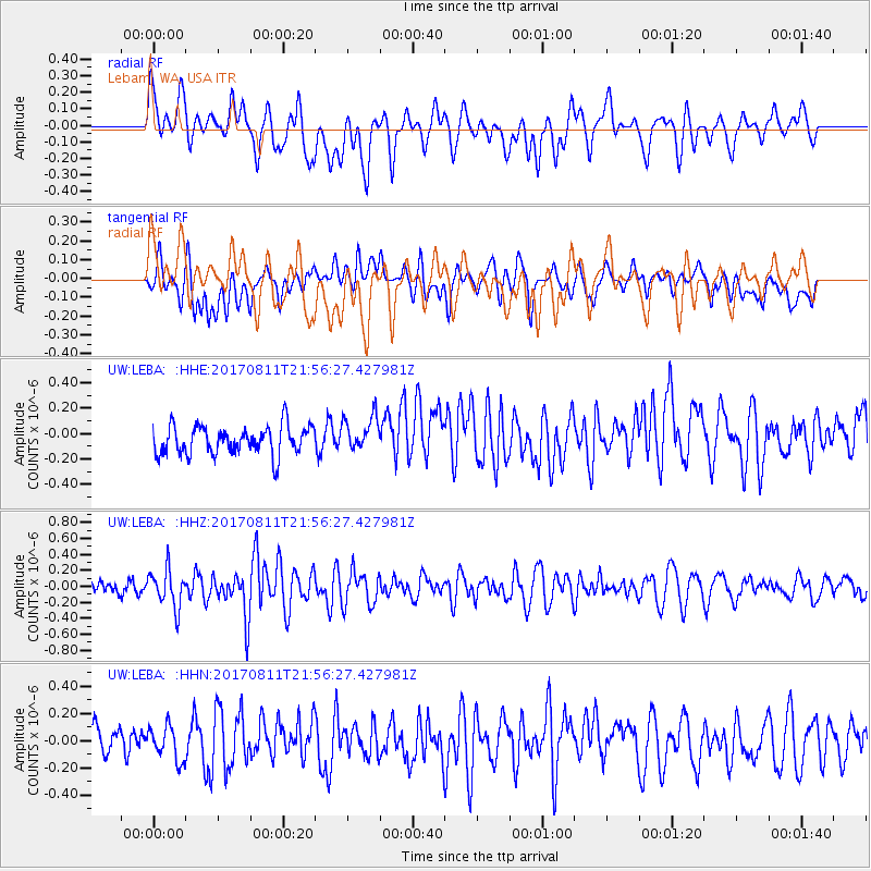
LEBA Lebam, WA, USA - Earthquake Result Viewer
*The percent match for this event was below the threshold and hence no stack was calculated.
| Earthquake location: |
Near Coast Of Peru |
| Earthquake latitude/longitude: |
-16.3/-73.5 |
| Earthquake time(UTC): |
2017/08/11 (223) 21:45:09 GMT |
| Earthquake Depth: |
35 km |
| Earthquake Magnitude: |
5.6 Mww |
| Earthquake Catalog/Contributor: |
NEIC PDE/us |
|
| Network: |
UW Pacific Northwest Regional Seismic Network |
| Station: |
LEBA Lebam, WA, USA |
| Lat/Lon: |
46.55 N/123.56 W |
| Elevation: |
73 m |
|
| Distance: |
77.1 deg |
| Az: |
327.105 deg |
| Baz: |
130.92 deg |
| Ray Param: |
$rayparam |
*The percent match for this event was below the threshold and hence was not used in the summary stack. |
|
| Radial Match: |
56.457428 % |
| Radial Bump: |
400 |
| Transverse Match: |
49.143497 % |
| Transverse Bump: |
400 |
| SOD ConfigId: |
13570011 |
| Insert Time: |
2019-04-28 14:07:42.321 +0000 |
| GWidth: |
2.5 |
| Max Bumps: |
400 |
| Tol: |
0.001 |
|
Signal To Noise
| Channel | StoN | STA | LTA |
| UW:LEBA: :HHZ:20170811T21:56:27.427981Z | 2.9604692 | 2.364673E-7 | 7.987494E-8 |
| UW:LEBA: :HHN:20170811T21:56:27.427981Z | 1.0480444 | 1.2518508E-7 | 1.1944634E-7 |
| UW:LEBA: :HHE:20170811T21:56:27.427981Z | 1.2127727 | 1.3479338E-7 | 1.111448E-7 |
| Arrivals |
| Ps | |
| PpPs | |
| PsPs/PpSs | |


