You are here: Home > Network List > TA - USArray Transportable Network (new EarthScope stations) Stations List
> Station 226A Malaga, Loving, NM, USA > Earthquake Result Viewer
226A Malaga, Loving, NM, USA - Earthquake Result Viewer
| Earthquake location: |
Kuril Islands |
| Earthquake latitude/longitude: |
51.0/157.6 |
| Earthquake time(UTC): |
2008/07/24 (206) 01:43:16 GMT |
| Earthquake Depth: |
27 km |
| Earthquake Magnitude: |
6.0 MB, 6.0 MS, 6.2 MW, 6.2 MW |
| Earthquake Catalog/Contributor: |
WHDF/NEIC |
|
| Network: |
TA USArray Transportable Network (new EarthScope stations) |
| Station: |
226A Malaga, Loving, NM, USA |
| Lat/Lon: |
32.06 N/104.10 W |
| Elevation: |
929 m |
|
| Distance: |
70.6 deg |
| Az: |
62.941 deg |
| Baz: |
318.456 deg |
| Ray Param: |
0.054817654 |
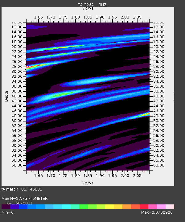
| Estimated Moho Depth: |
27.75 km |
| Estimated Crust Vp/Vs: |
1.61 |
| Assumed Crust Vp: |
6.232 km/s |
| Estimated Crust Vs: |
3.877 km/s |
| Estimated Crust Poisson's Ratio: |
0.18 |
|
| Radial Match: |
86.746635 % |
| Radial Bump: |
355 |
| Transverse Match: |
76.74775 % |
| Transverse Bump: |
400 |
| SOD ConfigId: |
2504 |
| Insert Time: |
2010-03-06 02:47:55.515 +0000 |
| GWidth: |
2.5 |
| Max Bumps: |
400 |
| Tol: |
0.001 |
|

Signal To Noise
| Channel | StoN | STA | LTA |
| TA:226A: :BHZ:20080724T01:53:58.048997Z | 12.282865 | 1.3912086E-6 | 1.13264186E-7 |
| TA:226A: :BHN:20080724T01:53:58.048997Z | 3.6409953 | 3.4414262E-7 | 9.451883E-8 |
| TA:226A: :BHE:20080724T01:53:58.048997Z | 3.7142117 | 2.8129796E-7 | 7.573558E-8 |
| Arrivals |
| Ps | 2.8 SECOND |
| PpPs | 11 SECOND |
| PsPs/PpSs | 14 SECOND |


