You are here: Home > Network List > TA - USArray Transportable Network (new EarthScope stations) Stations List
> Station 226A Malaga, Loving, NM, USA > Earthquake Result Viewer
226A Malaga, Loving, NM, USA - Earthquake Result Viewer
| Earthquake location: |
Tonga Islands |
| Earthquake latitude/longitude: |
-21.9/-173.8 |
| Earthquake time(UTC): |
2008/10/19 (293) 05:10:33 GMT |
| Earthquake Depth: |
29 km |
| Earthquake Magnitude: |
6.8 MB, 7.0 MS, 6.9 MW, 6.9 MW |
| Earthquake Catalog/Contributor: |
WHDF/NEIC |
|
| Network: |
TA USArray Transportable Network (new EarthScope stations) |
| Station: |
226A Malaga, Loving, NM, USA |
| Lat/Lon: |
32.06 N/104.10 W |
| Elevation: |
929 m |
|
| Distance: |
85.5 deg |
| Az: |
53.02 deg |
| Baz: |
240.926 deg |
| Ray Param: |
0.044658624 |
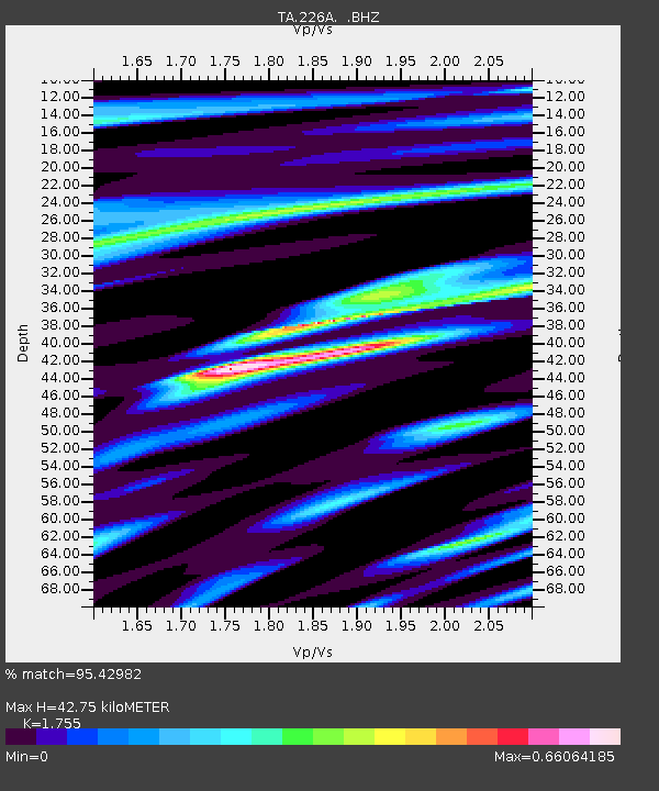
| Estimated Moho Depth: |
42.75 km |
| Estimated Crust Vp/Vs: |
1.75 |
| Assumed Crust Vp: |
6.232 km/s |
| Estimated Crust Vs: |
3.551 km/s |
| Estimated Crust Poisson's Ratio: |
0.26 |
|
| Radial Match: |
95.42982 % |
| Radial Bump: |
400 |
| Transverse Match: |
88.10042 % |
| Transverse Bump: |
400 |
| SOD ConfigId: |
2556 |
| Insert Time: |
2010-03-06 02:48:00.504 +0000 |
| GWidth: |
2.5 |
| Max Bumps: |
400 |
| Tol: |
0.001 |
|

Signal To Noise
| Channel | StoN | STA | LTA |
| TA:226A: :BHZ:20081019T05:22:37.899014Z | 48.859756 | 8.10332E-6 | 1.6584856E-7 |
| TA:226A: :BHN:20081019T05:22:37.899014Z | 11.481026 | 9.269946E-7 | 8.0741444E-8 |
| TA:226A: :BHE:20081019T05:22:37.899014Z | 10.47923 | 1.7583554E-6 | 1.6779434E-7 |
| Arrivals |
| Ps | 5.3 SECOND |
| PpPs | 18 SECOND |
| PsPs/PpSs | 24 SECOND |


