You are here: Home > Network List > TA - USArray Transportable Network (new EarthScope stations) Stations List
> Station 226A Malaga, Loving, NM, USA > Earthquake Result Viewer
226A Malaga, Loving, NM, USA - Earthquake Result Viewer
| Earthquake location: |
Vanuatu Islands |
| Earthquake latitude/longitude: |
-13.5/167.0 |
| Earthquake time(UTC): |
2008/09/08 (252) 18:52:06 GMT |
| Earthquake Depth: |
110 km |
| Earthquake Magnitude: |
6.4 MB, 6.9 MW, 6.9 MW |
| Earthquake Catalog/Contributor: |
WHDF/NEIC |
|
| Network: |
TA USArray Transportable Network (new EarthScope stations) |
| Station: |
226A Malaga, Loving, NM, USA |
| Lat/Lon: |
32.06 N/104.10 W |
| Elevation: |
929 m |
|
| Distance: |
96.2 deg |
| Az: |
58.632 deg |
| Baz: |
258.01 deg |
| Ray Param: |
0.040512715 |
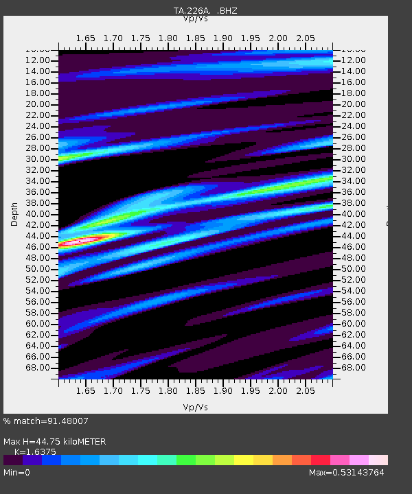
| Estimated Moho Depth: |
44.75 km |
| Estimated Crust Vp/Vs: |
1.64 |
| Assumed Crust Vp: |
6.232 km/s |
| Estimated Crust Vs: |
3.806 km/s |
| Estimated Crust Poisson's Ratio: |
0.20 |
|
| Radial Match: |
91.48007 % |
| Radial Bump: |
369 |
| Transverse Match: |
76.28678 % |
| Transverse Bump: |
339 |
| SOD ConfigId: |
2560 |
| Insert Time: |
2010-03-06 02:48:01.381 +0000 |
| GWidth: |
2.5 |
| Max Bumps: |
400 |
| Tol: |
0.001 |
|

Signal To Noise
| Channel | StoN | STA | LTA |
| TA:226A: :BHZ:20080908T19:04:51.024016Z | 7.799883 | 1.6789256E-6 | 2.1525011E-7 |
| TA:226A: :BHN:20080908T19:04:51.024016Z | 0.8848238 | 1.15284344E-7 | 1.3029074E-7 |
| TA:226A: :BHE:20080908T19:04:51.024016Z | 4.513458 | 4.7211245E-7 | 1.0460105E-7 |
| Arrivals |
| Ps | 4.7 SECOND |
| PpPs | 19 SECOND |
| PsPs/PpSs | 23 SECOND |


