You are here: Home > Network List > TA - USArray Transportable Network (new EarthScope stations) Stations List
> Station 226A Malaga, Loving, NM, USA > Earthquake Result Viewer
226A Malaga, Loving, NM, USA - Earthquake Result Viewer
| Earthquake location: |
Kermadec Islands Region |
| Earthquake latitude/longitude: |
-27.4/-176.3 |
| Earthquake time(UTC): |
2009/02/18 (049) 21:53:45 GMT |
| Earthquake Depth: |
25 km |
| Earthquake Magnitude: |
6.8 MB, 7.2 MS, 6.9 MW, 6.9 MW |
| Earthquake Catalog/Contributor: |
WHDF/NEIC |
|
| Network: |
TA USArray Transportable Network (new EarthScope stations) |
| Station: |
226A Malaga, Loving, NM, USA |
| Lat/Lon: |
32.06 N/104.10 W |
| Elevation: |
929 m |
|
| Distance: |
90.7 deg |
| Az: |
53.961 deg |
| Baz: |
237.836 deg |
| Ray Param: |
0.04165443 |
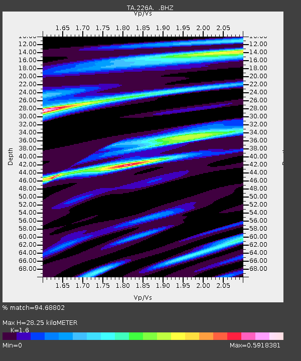
| Estimated Moho Depth: |
28.25 km |
| Estimated Crust Vp/Vs: |
1.60 |
| Assumed Crust Vp: |
6.232 km/s |
| Estimated Crust Vs: |
3.895 km/s |
| Estimated Crust Poisson's Ratio: |
0.18 |
|
| Radial Match: |
94.68802 % |
| Radial Bump: |
400 |
| Transverse Match: |
82.46451 % |
| Transverse Bump: |
400 |
| SOD ConfigId: |
2658 |
| Insert Time: |
2010-03-06 02:48:04.980 +0000 |
| GWidth: |
2.5 |
| Max Bumps: |
400 |
| Tol: |
0.001 |
|

Signal To Noise
| Channel | StoN | STA | LTA |
| TA:226A: :BHZ:20090218T22:06:14.050015Z | 11.991891 | 2.6558998E-6 | 2.2147466E-7 |
| TA:226A: :BHN:20090218T22:06:14.050015Z | 1.6966364 | 4.1997546E-7 | 2.4753416E-7 |
| TA:226A: :BHE:20090218T22:06:14.050015Z | 2.3899374 | 7.1455094E-7 | 2.989831E-7 |
| Arrivals |
| Ps | 2.8 SECOND |
| PpPs | 12 SECOND |
| PsPs/PpSs | 14 SECOND |


