You are here: Home > Network List > CH - Switzerland Seismological Network Stations List
> Station SLE Schleitheim > Earthquake Result Viewer
SLE Schleitheim - Earthquake Result Viewer
| Earthquake location: |
Southern Sumatra, Indonesia |
| Earthquake latitude/longitude: |
-3.8/101.6 |
| Earthquake time(UTC): |
2017/08/13 (225) 03:08:11 GMT |
| Earthquake Depth: |
36 km |
| Earthquake Magnitude: |
6.4 Mww |
| Earthquake Catalog/Contributor: |
NEIC PDE/us |
|
| Network: |
CH Switzerland Seismological Network |
| Station: |
SLE Schleitheim |
| Lat/Lon: |
47.76 N/8.49 E |
| Elevation: |
648 m |
|
| Distance: |
94.9 deg |
| Az: |
317.46 deg |
| Baz: |
90.253 deg |
| Ray Param: |
0.040914815 |
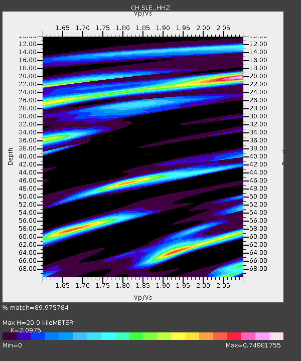
| Estimated Moho Depth: |
20.0 km |
| Estimated Crust Vp/Vs: |
2.10 |
| Assumed Crust Vp: |
6.416 km/s |
| Estimated Crust Vs: |
3.059 km/s |
| Estimated Crust Poisson's Ratio: |
0.35 |
|
| Radial Match: |
89.975784 % |
| Radial Bump: |
400 |
| Transverse Match: |
80.63956 % |
| Transverse Bump: |
400 |
| SOD ConfigId: |
13570011 |
| Insert Time: |
2019-04-28 14:17:20.668 +0000 |
| GWidth: |
2.5 |
| Max Bumps: |
400 |
| Tol: |
0.001 |
|

Signal To Noise
| Channel | StoN | STA | LTA |
| CH:SLE: :HHZ:20170813T03:20:58.045022Z | 7.77171 | 7.5497746E-7 | 9.7144316E-8 |
| CH:SLE: :HHN:20170813T03:20:58.045022Z | 1.2602258 | 6.152552E-8 | 4.8821025E-8 |
| CH:SLE: :HHE:20170813T03:20:58.045022Z | 3.8816702 | 2.3046879E-7 | 5.9373615E-8 |
| Arrivals |
| Ps | 3.5 SECOND |
| PpPs | 9.5 SECOND |
| PsPs/PpSs | 13 SECOND |


